Showing posts with label Samuel Lines. Show all posts

Tour of Lost Birmingham Nᵒ.38: Samuel Lines Captures the Bustling Centre (Victoria Square As It Was)

The Town Hall and Queen's College, painted c. 1848 by Samuel Lines Senior


Samuel Lines painted a number of topographical pictures of Birminghm. He produced the above in about 1848, but, at that time, would not have called this area Victoria Square, as it is called today. At this time Victoria was on the throne, but this space by the Town Hall became Victoria Square in the year the Queen died, 1901, when a statue of her was erected near to where it still stands today. The statue was perhaps erected here as when she visited Birmingham as Queen in 1858 she would alight from her carriage in this open area and enter a purple canopy of velvet into the Town Hall.

In Samuel Lines's painting, the area is a busy thoroughfare, just as it is today; the open space was formed naturally at a place where six streets met,* and the atmosphere of this bustling area was described in 1825:
'The junction of these streets is one of the most pleasing and lively spots in the town. An open space, receiving into one focus the radiation of six ways, there is a continual succession of objects; and being the centre of a busy manufacturing district, the throng of artizans [sic] leaving their several workshops, at the hour of One, and hurrying to their meal, has a particularly animated ans cheerful effect; especially in this time of plentiful employment.'**


Samuel Lines filled his painting with a selection of animated characters; there are cheeky schoolboys, workers grouped together chatting, an older man and a boy sitting under the lampost looking at a book, a genteel couple in a fine carriage (the lady turns towards the viewer), beggars, peddlars, a soldier in his smart red coat, a black or Asian man in orange and turquiose robes, and two workers carrying a huge urn among mant more. You can also see how the arches of the Town Hall could be walked through as two genteel ladies, dressed to impress, promenade through with a small dog. The size of these arches compared to the pedestrians beneath is very telling; the Town Hall would have been the largest building in the area by far (the church had a taller spire, but that was slim), it was a massive block of a building and must have felt huge to the inhabitants of the town. The ladies walking beneath are much smaller than they should be compared to the actual size of the arches, so Lines must have subconciously felt this a large building to make such a mistake.


Find out more about the buildings depicted in the painting below.


1) The wall of Christ Church
2) Corbett's Temperance Hotel, run by Joseph Corbett
3) Terraces built in about the 1760s
4) Queen's College (see below)
5) More terraces in the distance (see below)
6) The Town Hall
7) Druggist's shop, run by Samuel Wilson Suffield

Reconstruction using photographs, postcards and illustrations, of Queen's College and the buildings further along (unfinished) on Paradise Street, circa 1851, by Jenni Coles-Harris.

NOTES
* The six streets were Ann Street, Congreve Street, Hill Street, New Street, Paradise Street and Pinfold Street.
** References on request.

Tour of Lost Birmingham Nᵒ.36: Samuel Lines - From the Dome of St. Philip's


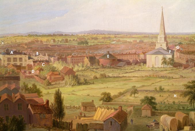
There are a number of topographical paintings of the absent landscape of Birmingham, but this one by Samuel Lines Senior gives one of the best impressions of the town as the perspective is taken from a central position outwards, rather than looking towards the whole town from a distance. It was painted in about 1821, and although it is not a panorama (as discussed in this previous post) as it does not go round 360 degrees, it is panoramic, in the sense that it is an elongated field of view like that captured by a wide angle camera-lens. Perhaps Lines was inspired by some of the cityscapes that could be visited in actual the Panorama on New Street (see E below), which encouraged him to produce this vista of Birmingham's own townscape. For his vantage point Lines took the highest point of the town, which happened to accommodate the church of St. Philip's and that building's large dome, and pointed himself south-west. This was in the direction of one of the newer parts of the town, an area that had expanded from the Medieval district from the 1750s onwards. At the fore of the image can be seen the graveyard attached to the church, and the buildings, some still very makeshift, of Temple Row, one of which was Lines's own house which he had built when he had started to do well as a drawing instructor.  In the close-up, below, some of the buildings and landmarks have been pinpointed, and you can follow the proceeding links to find out more.


A to E are along New Street
A) Is the Theatre, by the time of the painting, the Theatre Royal.
B) Next to the theatre was Portugal House, a grand Georgian town house, at the time of the painting divided into two properties with a distillery attached.
C) Just over the street is the original Georgian cottage Post Office, which had at its rear...
D) The Post Office yard where the Royal Mail coaches would arrive from 1812.
E) Is the Panorama, where 360 degree actual size paintings were shown.
F & G are in what is now Victoria Square
F) Is Christ Church, the interior of which can be viewed by following the link.
G) Is placed just to the left of the flag that topped Allin's shop, nicknamed The Flag as it always flew the Union Jack. The Town Hall was later built near this spot. In the distance, behind the 'G', is the Canal Offices on Paradise Street.
H) Is the walled garden attached to Bennett's Hill House, the house just out of view on the right. All the green land in that area was the original Bennett's Hill, and had been protected from building work by a clause in the 120 year lease for the house and land. The lease had expired in 1818 and not long after Lines's painting the whole are was built up with two new roads, houses, shops and other businesses.

View from 3 Temple Row West (Samuel Lines's house) drawn by Lines.
The drawing gives a similar view of the Theatre and Portugal House
as the painting and may have acted as inspiration. To climb on the roof
and look the growth of Birmingham must have fascinated Lines. 

To see all posts including Samuel Lines Senior's work click here.

NOTES
The painting and drawing are owned by BMAG and the painting is currently on display in the Birmingham History Galleries.
http://www.bmag.org.uk/new-birmingham-history-galleries

Portraits: Samuel Lines (1778-1863)

Samuel Lines Senior. By William Thomas Roden, 1863.

This short artist's profile is designed to give an insight into Samuel Lines (1778-1863), a topographical painter based in Birmingham whose work has been used on this blog. More will be added as information comes to light. He produced a wide body of work for over 50 years and was one of the most prominent artists in Birmingham in the first half of the nineteenth century. Three sons were also artists, Samuel Rostill, Edward Ashcroft and Frederick Thomas, to varying degrees.

Samuel Lines Senior was born in Allesley in Warwickshire and came to Birmingham in 1794 as an apprentice to a Mr. Keeling. He worked as a clock dial enameller and decorator, but also produced work for Henry Clay who ran a large manufactory on Newhall Street. Lines himself set up a drawing school on Newhall Street in the early part of the nineteenth century, which was a novelty for Birmingham, and the school prospered. He was soon able to build a house for himself and his family, on Temple Row, where he continued to teach. In 1809 he embarked on a project with three other local artists, Moses Haughton, Joseph Barber (whom Lines had studied under) and Charles Barber, to set up a life drawing school on Peck Lane, just off New Street. In 1814 the school, doing well, moved to larger rooms in Union Passage, and the same year they housed an exhibition which exhibited works from artists within a 30 mile radius of Birmingham. By 1821 the group had again outgrown their premises and consulted with wealthy patrons and local industrialists, the product of which was the formation of the Society of Arts which took up residence in the old Panorama building on New Street. This building was rebuilt in 1828. Lines took classes at the society and managed many of the exhibitions. In 1842 there was some disagreement within the society, which split into two, with the new group moving to rooms on Temple Row, called the Aetheneum.

Samuel Lines painted by Frederick Thomas Lines.
Year unknown. May be of Samuel Rostill Lines. 


Samuel Lines's Paintings and Drawings of Birmingham
with links to those that are included on this blog
Unknown date: Drawing, Bull Ring and Shambles
Unknown date: Drawing, The Birthplace of David Cox
Unknown date: Old Wagon Warehouse, Bennett's Hill
Unknown date: Dr. Freer's House in Cannon Street
Unknown date: Wheatsheaf and Shops, New Street
1800: Bradford Street and the Moat
1820: Interior of the Old Room at the Free School
c.1820: Drawing, The Top of Ann Street Towards St. Philip's
1821: Painting, Birmingham from the Dome of St. Philip's
1821: Drawing, View from Number 3 Temple Row West

1824: Post Office, New Street
1830: Bell Street
c. 1848: Painting, Birmingham Town Hall & Queen's College

1857: Painting, The Opening of Calthorpe Park (below, top)
1857: Painting, The Duke of Cambridge Leaving the Town Hall (below, bottom)


Tour of Lost Birmingham Nᵒ.32: The Bull Ring & the Spectacle of Bull Baiting (High Street)

Drawing by Samuel Lines Senior. Held by Birmingham Museum and Art Gallery.

The Georgian Bull Ring (part of Birmingham's market area, now a shopping centre) would have been a very crowded and muddled hodge-podge of buildings, many of which encroached over the roads and left scarce room for pedestrians, let alone carts. The Shambles was a group of butcher's shops, which can be seen on the right of the image, above, and filled the area leading to St. Martin's church (left). As the town grew this traditional market place became too small and crowded, and so, from 1801, the Bull Ring was cleared of many of the obstructions, including the Shambles. This was done by the Street Commissioners who were in charge of maintaining the town, and especially in keeping the markets running smoothly.

At the time when this whole area was cleared, a small metal ring was removed from the middle of the ground between the Shambles and St. Martin's church. These rings, that were found in other towns too (Ludlow still has a street called Bull Ring), were 'an iron ring that sticketh in the corne market, to which the bulles that are yearelie bated be usallie tied',* and it was one of these rings that had given the Bull Ring its name. Bull-baiting was a popular recreation in markets, dating back to origins perhaps in the 12th century. The bull would be attached to the ring and dogs would be set on it, this was thought to improve the quality of the meat and make it 'softer in digestion',* as well as provide 'sport' for the spectators in the market. In fact, there is evidence that bull baiting was developed not as an entertainment, but solely as the way to slaughter the meat of older bulls, which would often be tough, and was common practice for butchers.** It is no surprise that the Birmingham 'bull ring' was placed by the butcher's shambles, as it would be a short journey from the killed bull to having the meat then placed on sale.

There is very little evidence of the tradition of bull baiting in Birmingham's market, but if bull baiting began less as a sport and more as the common process of slaughter, this is not so surprising. The area known as the Bull Ring was first shown on the 1778 map, before that (1750 map) it was just the Shambles and the corn market recorded, so it could be that the ring was a late addition to the market area and the practice relatively short lived within the market place. Equally so, the actual ring could have been in place for many, many years, but the area only became known as the 'Bull Ring' at this time.

There are some mentions of bull baiting in the records. In the 1760s a man called John Cooper was given permission to bait a bull in the Bull Ring 'whenever he pleased' by the Lord of the Manor,* probably for the supply of baited meat, but Showell tells us that bull baiting was completely prohibited in Birmingham in 1773.* There were still attempts, though, to bait in and around the town in 1777:
'There have been great Disturbances in the Hamlets of Deritend, Erdington, Saltley, and other Places, in or near this town [Birmingham], occasioned by Bull-baiting, and other Methods made use of to collect disorderly People together, to the great Annoyance of the Publick Peace'.**
The reason for banning bull baiting at this time was less about any mistreatment of the animal and more about unruly groups of people and the 'unsanctioned use of the streets'.**

It was not till the early 1800s that the practice came under any real criticism with regards to cruelty to the animals involved. Although Birmingham was free from bull baiting by this time, many surrounding areas, especially in the Black Country, still maintained a number of blood 'sports', and complaints were issued in the Birmingham Gazette about the custom:
18 March 1828


The 'sport' was also thought to cause drunkeness, and alongside a blood-lust, consequently could lead to violence through fighting and domestic abuse, which are hinted at in the article. Bull baiting was finally banned by law in 1835, though the last known instance in England was in 1838 near Birmingham Heath on the outskirts of the town.*

Bear baiting in a provincial town, 1749. The bear is being
taunted and hit with wheel-barrows.


NOTES
Top image drawn by Samuel Lines Senior
* References on request
** Emma Griffin, England's Revelry: A History of Popular Sports and Pastimes, 1660-1830.

Tour of Lost Birmingham Nᵒ.27: Suffield's Druggist Shop (Corner of Congreve and Ann Street)

Section of Samuel Lines Senior's painting of the
area by the Town Hall in the late 1840s, with
insert of Samuel Wilson Suffield's druggist's
shop window. The full painting is on display
in the Birmingham History exhibition at BMAG.


During the late eighteenth and early nineteenth centuries, the difference between the apothecary and the druggist was subtle. Apothecaries had originally been spicers and/or grocers, but had split to form their own guild in London in 1617. The apothecary would be trained to some degree and would also visit and treat patients, whilst the druggists would just prepare and dispense medicines. In the early 1800s the apothecaries argued that they should have control of making up medicines and tried to get an act passed in Parliament; the druggists won the day though, when in 1815 the Apothecaries Act kept control with the druggists. The apothecary's role has developed into that of our GP's and the role of the druggist can be seen as to have evolved into our modern chemists, but confectioners can also trace their ancestry back to druggists and apothecaries as many modern sweets have developed from medicines. In fact, the bright colours and alluring jars of an old-fashioned sweet shop shout-out "apothecary shop" more than any branch of Boot's Chemist.

Find out more about Birmingham's historic health and wellbeing, here.

In the late 1840s, artist Samuel Lines captured the druggist's window of Samuel Wilson Suffield's shop, which was situated near the Town Hall.** Suffield had run his business at the castellated shop from around the late 1810s (before Suffield the shop was run by William Allin as a tailor's and cabinet of curiosities, you can visit this shop here). The druggist, or apothecary, would display their skills by mixing chemicals to produce vivid colours which would then be placed in large glass jars in the shop window; you can see them on display in Suffield's window in the close-up above.

Some suppliers were unscrupulous and mixed drugs with cheaper, and sometimes dangerous substances in order to make more profit. It was often hard to control these practices as imported goods could be tampered with before they arrived in the hands of even the wholesale druggist. Suffield seems to have had some trouble with one such supplier: D. Carr and Co. The article below, from June 1828, describes how he had to replace his entire stock from the 'most respectible houses' obviously after some unmentioned incident. What is interesting, though, is that it lists in some detail, a selection of some of the products that he supplied and their cost, and shows how the druggists work intertwined with making chemicals for cleaning.


Inside a Druggist's Shop
 
Image of an apothecary from The Book of Trades or Library of Useful Arts,
Part I, printed in 1804.

Druggist's drawers from a Hall Green shop, in the collection of
Birmingham Museums and Art Gallery.
.

NOTES
The BMAG website is here.

Another Birmingham apothecary touched upon is in my post: Pratchett's Bull Ring, and another briefly in 'I have forever quited Birmingham'
** Samuel Wilson Suffield went bankrupt in 1844, I have been unable to discover whether he continued in business after bankruptcy. The druggist shop was definitely closed by 1849 when the Bryan family opened their coffee, pastry and confectionery shop in the building.

Tour of Lost Birmingham Nᵒ.7: Bennett's Hill House and Gardens (Bennetts Hill and Ann Street (Colmore Row))

Top of Newhall Street, looking towards St. Philip's and Bennett's Hill House.
Probably by Samuel Lines Senior.

The sketch above is recorded in the archive as being made in 1828, though it may possibly be earlier that decade as the house on the far right was most likely taken down when Bennett's Hill was cut in the early 1820s. The three storey house just to the left is Bennett's Hill House, and the land that the road 'Bennett's Hill' was built on (as well as Waterloo Street) was attached to this house. The house was built in 1698 by the wealthy iron merchant, John Pemberton, with a lease for the land of 120 years, but it was his son, Thomas, that added the fashionable gardens to the house in the early 1730s. He initially added a walled garden and then planted long walks lined with trees (see map). A visitor to the house in 1755 described the gardens:
‘[They] consist of two parts, a handsome flower-garden about half an acre, square and walled in; neatly laid out, and as neatly kept. On the left hand stands a convenient summer-house, opposite to which is a gate opening to a long grass-walk, having a row of fan elms on each side, with borders of various kinds of plants and flowering shrubs; this walk parts the fruit and kitchen garden; at the end is another walk on the left hand, with rows of tall fir-trees, etc. The house stands on the highest ground of the town, over which the garden commands a good view of the country on that side for some miles.’*


Part of T. Underwood's copy of the 1731 south-west prospect of Birmingham
Bennett's Hill House is under the star, and the hill infront is Bennett's Hill

During this period the fashion for public walks and promenards expanded. Walks were sociable environments, a place for 'refined' people to meet similar friends and acquaintances, and a place to meet prospective spouses. St. Philip's church, which can be seen to the right of Bennett's Hill House in the image above, had a public walk attached to its grounds throughout the middle of the eighteenth century. The gardens and walks at Bennett's Hill House although private, show the 'walk' as a popular leisure pursuit of the wealthier classes of the time, and Pemberton's personal gardens asserted his personal wealth and pre-eminence within the town. They would have been enjoyed by the Pemberton's and their wealthy friends and acquaintances.

About 15 years after the 1731 prospect was drawn, Thomas Pemberton must have felt that the rural ambience of his gardens was under threat by the growing town, as he added terms to the family's 120 year lease that the land could not be built on the the term of the lease. This meant that as the town grew up all around, Bennett's Hill became marooned from the rest of the countryside, and a green enclave in the bustle of Birmingham. Ann street which passed it leading to St. Philip's became known as Mount Pleasant, probably because it was such a pleasant walk from St. Philip's down to the newly developed middle-class areas of the town.  From 1794 to 1817 a hay market was held on the hill, and in 1805 a site at the bottom corner was negotiated for the building of Christ Church, a church with free pews for the poor. In 1818 the 120 year lease expired and the land could then be built on, and two new streets, Bennett's Hill and Waterloo Street were laid out across what had been the Pemberton gardens. The house itself remained until 1849.


Bennett's Hill House, shortly before demolition.

 NOTES
* References on request
Images courtesy of Birmingham Library and Archive Services

Tour of Lost Birmingham Nᵒ.2: Georgian Post Office (New Street)


The Post Office (right) and other shops on New Street in 1824.
By Samuel Lines Senior

It is easy to forget in this information age, when you can communicate with the other side of the planet within seconds, that the only way to be in contact with those outside of the town in the Georgian era was either to go and visit them or through the post office. The post office was very much the hub of communication in the Georgian town; it was where information was transmitted, not only through letters, but the post office was where you could find news of distant wars and current events, when newspapers were a luxury to many. The buildings life and history was discussed in a column of the Birmingham Daily Post in the 1860s; it was a nostalgic look back, and also, an attempt to comprehend the rapid change that was happening at the time. This post narrates the memories from those articles as well as other sources to understand what was being recorded in the drawing above by those who could actually remember.

For many wealthier visitors to the town, the post office would be their point of arrival, if they had taken the mail coach at least, alighting in the yard behind and walking out into New Street. In front of them would be the Theatre Royal and Portugal House, behind them appearing from behind the trees would be the Baroque tower of St. Philip’s, three of the finest buildings of the town, and this would be their first impression. The post office building itself had either been built or appropriated in about 1784 and was a simple unassuming Georgian house covered with rough stucco and whitewashed. The door to the office was on the right, with a small window for posting letters out of hours that was lit at night by an oil lamp and space for only about six people inside.* In the drawing the step outside has become worn from its service to many feet. To the right was a small outbuilding with a window where the notices would be placed, it was here where news of the Battle of Waterloo was posted.* The house of the postmaster, John Gottwaltz, was entered by a separate door surrounded by elegant Classical porch.

If you turned right out of the coach yard, passing the post office on your right, you would follow the wall of the Gottwaltz garden for a bit, with trees bowing over the top, and then find premises hiring out post horses and hackney coaches. Post horses were not just for the fast delivery of mail, but could be hired for carriages; often someone with their own carriage would start out with their own horses, but for long journeys the horses would need to be rested and then returned home, and the traveller could hire the post horses to the next town, and so on till their destination was reached. Hackney coaches were rented four wheeled vehicles, with or without a coachman, but were thought of socially as an inferior mode of transport to the mail coaches which delivered the post. The mail coach was usually how someone with means but who could not afford their own carriage would arrive in a town from afar.

The first mail coach to deliver and collect from Birmingham was in 1812 (though mail coaches began in 1784), it would have delivered to the local inns and clattered up Georgian New Street through the post office gates. The coaches all looked the same; large red wheels with maroon on the lower body and the doors and a black upper body. Each door was painted with the royal arms as well as the words Royal Mail, and on the side of the drivers carriage the letters GR were intertwined for George Regina. The panels on either side of the doors were painted with stars of the principal orders of the knighthood; the garter, bath, thistle and St. Patrick, and painted on the rear was the coaches individual number.* Each coach carried a driver and an armed guard both wearing smart red uniforms but with different coloured collars so that they could be distinguished from each other. The guard was responsible for locking the mail in a box at the rear of the coach. Sometimes the guard would hand over his watch to the postmaster to be checked and repaired to maintain the good time keeping of the coaches.

~A Georgian mail coach (produced circa 1870); the heads from this scrap have been lost.~


In about 1820 a brand new street, Bennett’s Hill, cut down onto New Street straight past the post office, which was at that time extensively altered. Bennett’s Hill sat where the yard and its gates had sat, and no more mail coaches disembarked at the post office; mail and visitors instead arriving at one of the towns several inns and hotels. This post office was run by John Gottwaltz’s unmarried daughter, Georgina Margaret, who had taken over when her father died in 1817, and who moved with the post office as it transferred over the street to the converted Portugal House in 1842. The old building was taken down shortly afterwards.

NOTES
*From Kirsten Olsen, All Things Austen (Oxford: Greenwood World Publishing, 2008).
Images courtesy of Birmingham Library and Archive Services.
To find out more, click the labels below.
Any questions? Please add them to the comments section, below.

Street By Street: Old Bull Street (Ancient Times-Present)


Bull Street formed a junction with Colmore Row (the top part was called Monmouth Street until about 1841), Snow Hill, and Steelhouse Lane at its north end, and with Dale End and High Street at its south end. Beginning in 1878 work began on building the new Corporation Street, which cut through Bull Street and meant that part of it was knocked down.

Image above: The 1841 vista of Birmingham should not be taken as a literal representation of Birmingham, but it provides an impression of Bull Street in the early years of Queen Victoria's reign.

Image below: The image below shows the entire west side of Bull Street in 1840, so around the same time as the vista, above. The top row shows numbers 109-81, and the bottom row shows numbers 80-54 (street numbers went in order at this time, not evens one side and odds the other - that was a Victorian invention).
Walk Up the West Side of Bull Street
Left to Right (109-54)

Held at Birmingham Archive.

Bull Street from High Street, by Samuel Lines, c. 1835.
Held by Birmingham Museums.

Image above: At the corner of Bull Street and High Street was a timber framed building called the Old Lamb House (see post here), demolished in 1886 (photograph taken shortly before demolition). This shows some of the age of Bull Street. This was 108 and 109 Bull Street.

Image Below: Another old house was at 105 Bull Street. In the 1849 directory of Birmingham this was a woollen drapers' run by Whilock Smith.

'Part of a House in Bull St', lithograph by Thomas Underwood, 1865.
Taken from The Buildings of Birmingham Past and Present.

Image below: This conjectural image, certainly produced with help of the street view of the west side (above) shows 93-93 Bull Street where the Cadbury family ran two shops. Number 93 was the tea shop which began selling a new chocolate drink during the Victorian period. Number 92 was the Cadbury drapers' shop. The scene is set in about the 1840s or 1850s. 


Image Below: The photograph below shows some of the surviving Georgian houses. Depicted are numbers 81-79 with a small slice of 78 on the right. Number 81 Bull Street was being by J. Page as a mantle and shawl warehouse both in the photograph below and in the 1840 illustration above. 


Walk Down the East Side of Bull Street
Left to Right (53-1)

The Quaker Meeting House with blocked up windows, sometime between 1793 and 1857.


Quaker Meeting House was built in 1702 at the top end of Bull Street. In 1793 the site was extended and the windows at the front bricked up. A new Meeting House was built in its place in 1857, which was set well back from the street behind the frontages. Iron Room / Leaflet ?Number 40 Bull Street at the time of the 1841 vista.

Photograph by Phyllis Nicklin, 1960.

Image above: The sign above Simpson, the fishmonger, states that it was established in 1790, and it was still going strong in this photograph from 1960. It was at 6 Bull Street, so the Georgian building to its right was 5 Bull Street.

http://epapers.bham.ac.uk/296/

Images below: At the bottom end of Bull Street where it met Dale End was a rounded building, seen in both the 1841 vista and Samuel Lines's 1835 drawing (both above). This was 1 Bull Street. In the photographs below it was run by Reece Bros as 'Ye Oldest Tobacconyst Shop in Bermyncham'. From at least 1829 to 1849 the tobacconist at number one was Joseph Smout

Bull Street, c. 1888.

Bottom end of Bull Street with the not yet demolished Old Lamb House, so before 1886.