Showing posts with label Views and Prospects. Show all posts

Birmingham Bookshop Nᵒ.4: South View of from "A History of Birmingham" by William Hutton (1782 (1783 edition))

South view of Birmingham from the summer house, Cheapside, Bordesley, c. 1782.
Click to enlarge.

In 1782 the first history of the town of Birmingham was published by William Hutton, and the image above, depicting a vista of the town, was added as the frontispiece (the image correlates nicely with the 1778 map). Hutton had first come to Birmingham nearly forty years previously and had found it a fascinating town; he was very fond of the place, and his history finally recorded the town's growth on paper.

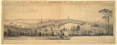
Views and Prospects Nᵒ.4: East Prospect of Birmingham by the Buck Brothers (1753)

East Prospect of Birmingham by Samuel and Nathaniel Buck, 1753.
Click to enlarge. Held by Birmingham Museums. Full size version, here.

This is a pencil, pen and ink wash of Birmingham produced by one of the Buck brothers as part their production of many town prospects for the Buck's Views series. When the image was engraved and published it included mid-Georgian men, women, and children strolling in the green and open foreground and a key of the principle buildings. It was reprinted in a coloured version in 1774 by Robert Sayer (below - poor image).

Views and Prospects Nᵒ.3: The East Prospect of Birmingham by William Westley (1732)


It seems apt that the first post for the new look should be about the East Prospect of Birmingham which has been used for the top image of the blog. It was made by William Westley in 1732, who also produced the 1731 map of Birmingham, so the two relate to each other nicely.

The prospect shows a thoroughly modern town, filled with brick (and they would have been red brick) buildings; a brand new church in the fashionable Baroque style (St. Philip's) on the highest point; and neat, uniformed streets in the 'new' town right of the church, including the new 'Square' built for the wealthy, and a modern innovation in early Georgian urban planning. It was Westley that produced this image as it was a view that his family's fingerprints were all over. His father, William Westley Senior, had worked on St. Philip's (the architect was Thomas Archer) and had built some of the surrounding streets (one was called Westley's Row); he was probably the man behind the 'Square' too. The Westley's had designed refinement and modernity into the fabric of the town, and were now promoting it in the beautiful East Prospect, and the map produced the previous year.


In a central engraving Westley dedicates the prospect to his 'Worthy Patrons' Thomas Archer and Henry Archer, Thomas of course being the architect of St. Philip's. The engraved stone is flanked by symbols of Birmingham's industry and refinement; a palette and mechanical devices on the left, and musical instruments on the right. The town is also described:
“BIRMINGHAM, a Market Town in the County of WARWICK, which by the art and industry of its Inhabitants has for some years past been render’d famous all over the World, for the rare choice and invention of all sorts of Wares and Curiositys [sic] in Iron, Steel, Brass &c. admir’d as well for their cheapness, as their peculiar beauty of Workmanship [...]”
The description of Birmingham's wares as 'curiosities' was the spark of my PhD thesis at the University of Birmingham,* and is referring to Birmingham 'toys' (small metal items NOT children's toys) and trinkets that were highly desirable commodities of the time. The poet William Shenstone, who lived at Leasowes in Handsworth near Birmingham, was a great lover of these toys, and noted 'I have often viewed my watch, standish (inkstand), snuff-box, with this kind of tender regard; allotting them a degree of friendship, which there are some men, that do not deserve'. Birmingham was already renowned for these items, and became even more so over the next century, becoming known as the 'Toy-shop of Europe'. Birmingham was supplying everything modern and fashionable, and Westley is showing the actual space of the town as the same.


A CLOSER LOOK AT THE PROSPECT

Below you can see Digbeth, a street that shot out south-east from Birmingham, and led to the neighbouring village of Aston, over the River Rea. To the left is St. John's chapel which served the community that huddled along the river, using the waters for tanning leather and powering mills and forges. St. Martin's is the church with the tall spire, still standing today, but rebuilt completely. To the left of St. Martin's is the moated manor house, which was the seat of the old 'de Birmingham' family, a remnant of the town's mediaeval history. The old Birmingham estate can be seen rolling towards the horizon, with Edgbaston Church a dot in the distance (far left).

Digbeth 300 years ago. 1732 Prospect & 1731 Map of Birmingham, by William Westley

Below St. Philip's can be seen on the hill, and the area around was being slowly filled with brand new houses for the Birmingham elite, whose wealth was growing rapidly as the town's trade in luxury wares expanded. One of these was Westley's Row which was near the Square (see pointing finger), which was frequented by Samuel Johnson, among other notable persons of the time. In the foreground is a stretch of the River Rea not on the map, and it is nice to see a party fishing on its banks, especially as the Rea here today flows morosely under the streets along brick culverts.

St. Philip's and the Square. 1732 Prospect & 1731 Map of Birmingham, by William Westley


Views and Prospects Nᵒ.2: The South-West Prospect by the Buck Brothers (1731)

Birmingham nearly three hundred years ago.

The vista of Birmingham, above, is a copy of one first produced in 1731, as the town was growing and beginning to achieve fame and prominence as a centre for industry and ingenuity. In the distance the landscape is one of rolling green fields, and from the vantage point taken, you can see the spire of Yardley Church (on the right), Whitacre, Curdworth, as well as Charlbury Forest in Leicestershire. It was produced by Samuel and Nathaniel Buck, who visited Birmingham in 1729 to take initial drawings (see below).

The inscription written at the bottom is added below:

"BIRMINGHAM (anciently written BIRMYNCHAM also BRYMYNCHAM) is neither Borough nor Corporation; but remains, what it was before the Norman Conquest, only a Lordship: nevertheless, by the Industry & Ingenuity of its Inhabitants & the Advantage of its being an open free place of Trade, it is become famous for the vast Quantities of Iron & Brass, besides, Thread and Leather &c. manufactured there, and risen to A Competition with any of the most flourishing Towns in England being adorn’d with several beautiful Structures, such as a New Church: a Charity School, wherein are maintain’d and taught upwards of 50 Boys & Girls and a Free Grammar School founded and endow’d with a large revenue by King Edward teh sixth now rebuilt in a stately and commodious form. The Town is govern’d only by two Constables & holds a large Weekly market on Thursday, with two Annual Fairs, one on Ascension day, & the other on the feast of St. Michael. ____________ 1. New Hall. 2. St. Philip’s Church. 3. The Road to Worcester. 4. The Free School. 5. The Market House. 6. The Parsonage. 7. Charlbury Forest in Leicestershire. 8. St. Martin’s Church. 9. Curdworth. 10. Whitacre. 11. Lady’s Well. 12. The Manor House. 13. Digbeth. 14. The Bridge. 15. The River Rea. 16. St. John’s Chappel in Deritend. 17. Collshal. 18. Yardley."

The landmarks listed have been numbered more clearly below.


Below is one of the original drawing that the Buck's produced in 1729.

Drawing for the later printed prospect, pen and Indian ink with wash over pencil, 1729.
Held at Birmingham Museums (1934P399).

Views and Prospects Nᵒ.1: South-East View of Birmingham (c. 1656)


This prospect was produced in about 1656 by Wenceslaus Hollar showing the south-east part of the town with St. Martin's church to the left (see below also). This before it was encased in red sandstone in about 1692, which was designed in the neoclassical style. Many of the buildings would have still been timber framed, but newer buildings were beginning to be influenced by the classical styles, like the house probably built for John Jennens on the High Street, later becoming the Court of Requests.


The print was included in William Dugdale's History of Warwickshire (London: 1656), held at Birmingham Archive.
559306

Full Size Version of East Prospect of Birmingham by the Buck Brothers (1753)

 See the original post for this item, here.

East Prospect of Birmingham by Samuel and Nathaniel Buck, 1753.
Held by Birmingham Museums.