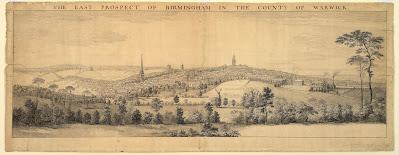
SCROLL DOWN TO SEE A LARGER IMAGE OF THE MAP
The coloured version by Alicja Borowska is sold by Paul Leslie Line who runs Map Seeker, and has also written a book which you can buy from Amazon
here.
The text on the left side of the map (top the bottom) is as follows.
'A PLAN OF
BIRMINGHAM
Surveyed in MDCCL [1750]
BY
SAMUEL BRADFORD
and Engraved by
Thomas Jefferys GEOGRAPHER
to His Royal Highness the
Prince of Wales'
'Birmingham is a Market Town situated in the North West part of the County of WARWICK [...] distant from London 88 computed & 116 measured Miles, the present number of Houses are 4107 & Inhabitants 23688.----------'
'This Town has been suppos'd to derive its name from one Birming whose dwelling-house formerly stood here. Ye termination Ham in ye Saxon Langueage signifies home or dwelling place. In ye reign of Edward the Confessor it was the Freehold of one Vluvine & in that of William the Conueror was in possession of William Fitz Ausculf who then resided at Dudley Castle. Henry II by a Grant allow'd them to hold a Market every Thursday in y' Year. In ye 35th of Henry III a Charter was given for two Fairs to be kept annually; one to begin on ye Eve of Holy Thursday, & the other on the Eve of St. John the Baptist.-----------'
'K. Edward VI in the 5th Year of his reign erected a Free Grammar School for Boys which is little inferior to any School in England as to its Revenues. St. Philip's Church was erected in the Reign of King George I who gave 600L toward the finishing of it.----------'
'St. Bartholomew's Chappel was lately built and consecrated in the Year 1750. This Town tho' very large and populous has only two Churches and two Chappels, Viz. St. Martin's & St. Philip's Churches, St. Bartholomew's Chappel which belongs to St. Martin's Parish, and St. John's Chappel in Deritend belonging to the Parish of Aston. [...] there are several Meeting Houses for Dissenters of almost all denominations. A Charity School for Boys & Girls & a large handsome [sic] Workhouse. This Place has been for a long series of Years increasing in its buildings & is superior to most Towns in ye Kingdom for its elegance and regularity, as well as Number & wealth of teh Inhabitants, its prosperity is owing greatly to ye Industry of ye People who have for many Years carried on an extensive Trade in Iron and other Wares especially in the Toy Business which has gain'd the Place a name & great esteem all over Europe.----------'
SCROLL DOWN TO SEE A LARGER IMAGE OF THE MAP
The table on the left-centre of the map is an '
An Alphabetical List of the Streets, Lanes &c. with the Number of Houses and Inhabitants in each'. It lists all of the streets that you can see on the map, how many houses were on each street (listed below as #h) and the number of inhabitants in the whole street. It has been suggested that Bradford did simple calculations to estimate the number of inhabitants in each street, though the average number of inhabitants (in square brackets[ ], calculated by myself) varies to such a degree that would suggest a more thorough calculation. The average population of the streets ranges between 3 (in a single house on Butts Lane) and 8.88 (for Cannon Street & Needless Alley), but because we do not know how Bradford collected his data, the information is less useful. For example, the Square has a very high average number of inhabitants at 8.08, yet it is known that this was an area resided in by the very wealthy, so the high average does not represent poverty; though it may represent a large number of in-living servants, but without more data this can only be presumed. The list follows though, for general interest, but please remember that the average inhabitants data is my own addition.
STREET: #houses then number of inhabitants in street [average inhabitants per house]
ASTON STREET & UPPER GOSTY GREEN: 54h
294 [5.44]
BELL STREET: 39h
179 [4.59]
BEWDLEY STREET: 14h
53 [3.79]
BORDESLEY: 83h 405 [4.88]
BUCKLE ROW: 5h 19 [3.8]
BULL STREET: 140h 819 [5.85]
BULL LANE: 14h 80 [5.7]
BUTTON ALLEY: 4h 18 [4.5]
BUTTS LANE: 1h 3 [3]
CANNON STREET & NEEDLESS ALLEY: 64h 568 [8.88]
CARRS LANE: 36h 207 [5.75]
CASTLE STREET: 25h 162 [6.48]
CHAPPEL ROW: 7h 33 [4.71]
CHAPPEL STREET: 43h 205 [4.77]
CHARLES STREET: 8h 31 [3.88]
CHERRY STREET & CROOKED LANE: 28h 190 [6.79]
CHURCH STREET: 2h 9 [4.5]
COLESHILL STREET: 37h 199 [5.38]
COLEMORE [COLMORE] ROW: 36h 268 [7.44]
COLEMORE [COLMORE] STREET: 58h 359 [6.19]
COOPERS MILL LANE: 7h 25 [3.57]
CORBETTS ALLEY: 4h 19 [4.75]
CORN CHEAPING: 29h 162 [5.59]
CROSS STREET: 1h 4 [4]
DALE END: 181h 932 [5.15]
DERETEND: 198h 1096 [5.34]
DIGBETH: 303h 1646 [5.43]
DOCK ALLEY: 13h 51 [3.92]
DUDDESTON STREET: ----
DUDLEY STREET: 104h 602 [5.79]
EDGBASTON STREET: 151h 879 [5.82]
FARMER STREET: 7h 27 [3.86]
FREEMAN STREET: 16h 137 [8.56]
FROGGARY: 25h 147 [5.88]
ST. BARTHOLOMEW'S STREET: ----
HANDSES SQUARE: 26h 140 [5.38]
HARLOW STREET: ----
HIGH TOWN: 247h 1565 [6.34]
HILL STREET: 3h 16 [5.33]
HINKLEYS: 37h 275 [7.43]
JENNING STREET: 1h 5 [5]
JOHN STREET: 59h 348 [5.9]
KING STREET: 36h 217 [6.03]
LEEK STREET: ----
LEASE LANE: 23h 148 [6.43]
LITCHFIELD STREET: 104h 841 [8.09]
LIVERY STREET: ----
LOWER MINORIES: 11h 58 [5.27]
LOWER PRIORY: 17h 90 [5.29]
ST. MARTIN'S LANE: 11h 49 [4.45]
MASS HOUSE LANE: 16h 77 [4.81]
MILL LANE: 16h 114 [7.13]
MOOR STREET: 195h 1076 [5.52]
MOAT LANE: 43h 252 [5.86]
NEW STREET: 109h 649 [5.95]
NEW MEETING STREET: 21h 149 [7.1]
NEWPORT STREET: 1h ----
NEWTON STREET: 54h 312 [5.78]
OLD MEETING STREET: 34h 231 [6.79]
PARK STREET: 156h 944 [6.05]
PECK LANE: 35h 187 [5.34]
PHILIP STREET: 38h 213 [5.61]
PINFOLD STREET: 97h 532 [5.48]
PITT STREET: ----
POTTER STREET: ----
QUEENS ALLEY: 10h 45 [4.5]
SAND STREET: 1h 4 [4]
SHUTT LANE & WELL COURT: 7h 55 [7.86]
SLAINEY [SLANEY] STREET: 60h 302 [5.03]
SMALLBROOK STREET: 101h 795 [7.87]
SNOW HILL: 84h 471 [5.61]
SPICER STREET: 41h 249 [6.07]
SQUARE: 16h 129 [8.06]
STAFFORD STREET & DITCH: 85h 408 [4.8]
STEELHOUSE LANE: 122h 645 [5.29]
SWINFORD STREET: 5h 19 [3.8]
TEMPLE ALLEY: 3h 19 [6.33]
TEMPLE ROW: 17h 129 [7.59]
TEMPLE STREET: 53h 316 [5.96]
THOMAS STREET: 52h 316 [6.08]
TONKES STREET: 13h 57 [4.38]
UPPER MINORIES: 4h 4 [1]
UPPER PRIORY: 23h 155 [6.74]
WALMER LANE: 2h 9 [4.5]
WEAMAN STREET: 78h 486 [6.23]
WESTLEY STREET: 68h 402 [5.91]
WOOD STREET: 35h 204 [5.83]
WORCESTER STREET: 66h 349 [5.29]
Houses Inhabited: 4058
Houses Uninhabited: 182
Total Inhabitants: 23,688