Showing posts with label Maps and Topography. Show all posts
Map of Warwickshire, c. 1646
Map of Warwickshire by Jan Jansson produced in about 1646, held at Boston Library in the US (original 42cm by 52cm).
The map shows several coats of arms for the local nobility including Thomas Percye, Richard Nevill and John Dudley.
A close-up of the Birmingham area and a large-scale image are below.
Map of Warwickshire, 1630
A map of Warwickshire produced by John Speed (1551/2-1629) and published in 1630. Birmingham and its surrounding villages can be seen in the top left (see below). There are also detailed maps of the towns of Warwick (Warwicke) and Coventry (Coventree). An original is held at Boston Public Library and can be viewed here.
Map of the Hundreds of Staffordshire, c. 1650
![]() |
| Map of the hundreds of Staffordhire, by Hollar, c. 1650s. |
Although this is a map of Staffordshire, the town of Birmingham can be seen at its borders on the left, and some of what are now the suburbs of Birmingham were previously in Staffordshire. On the map, north is to the right (one of the enlargements - below - is tilted with north at the top). It was produced in about the 1650s by Wenceslaus or Wenceslas Hollar, a Czech etcher, who made several images in the British Isles, and died in London in 1677. The original is 19 by 26 cm, and part of the Wenceslaus Holler Collection at the University of Toronto (see here).
Tour of Kings Norton & Northfield: The Northfield Map of 1714.....What Remains?
The central part of Northfield parish around the church, as drawn in 1714. Northfield is now a heavily urbanised suburb of Birmingham, six miles south of the centre, but at this time was a village surrounded by farmland. The area around the church is still a reminder of Northfield's Georgian, and even more distant part; with a Norman arch set into the wall of the church, this site has hundreds of years of history. So, what still remains from the time of the map?
![]() |
| The Village Pound, Northfield, 1953. Phyllis Nicklin. |
The pound, which can be seen on the centre-left of the map, was used to tether animals that had escaped their owners, who would have to pay a small fee to have them returned.
![]() |
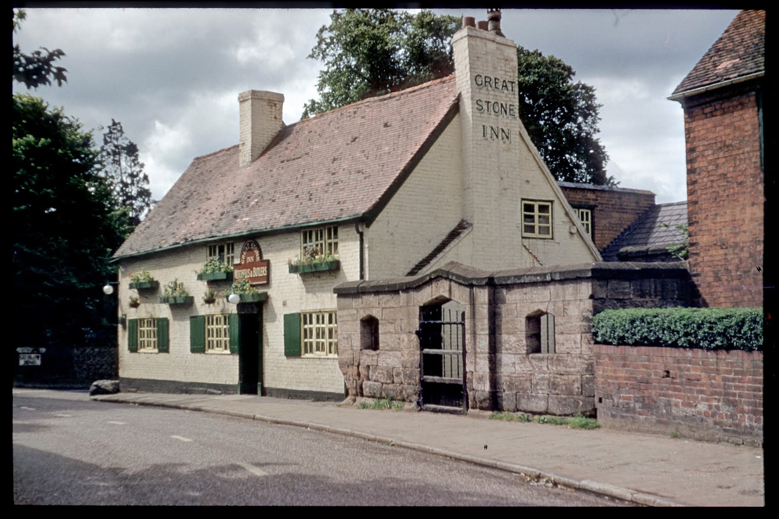
| The Great Stone Inn, next to the pound, 1953. Phyllis Nicklin. |
The Great Stone public house can seen just beneath the village pound on the map, but in reality the two are joined. The name derives from the 'great stone' that was situated at the corner of the pub, which has now been moved (the reason being pretty self explanatory from the image below) and placed inside the Village Pound for safe keeping.
![]() |
| The 'great stone' outside the Great Stone |
At the top of the map, the road leading off to the right states that it leads 'to Middleton Hall'. This road remains as Middleton Hall Road, the remnant of a long demolished smart dwelling house.
![]() |
| The scene including the church by Arthur Lockwood, 1958. |
The parish church can be seen at the bottom of the map, with a path cutting across to the vicarage. The scene that Arthur Lockwood depicted in 1958 is the same as today's, except devoid of cars.
A Walk Round Regency Brum with the 1819 Map
This map was published in 1819 and was included in the book A Description of Modern Birmingham by Charles Pye. The book also includes observations of the town which fit nicely with the map, and can be found online here. The angle is slightly skewed, with north towards the right.
Below: The buildings in the map have been colour co-ordinated and have an index underneath so that you can find out more about them. Not all the buildings have posts written about them, but they will slowly be added. West is at the top of the map.
BIRMINGHAM in the Year 1819
Click on the orange links below to find out more about each of the buildings on the 1819 map.
RED SECTION
Around St. Philip's Church
1. St. Philip's Church
2. Royal Hotel- Temple Row
3. Rectory of St. Philip's
4. Blue Coat School
ORANGE SECTION
New Street and area behind
top to bottom
1. Christ Church- New Street
2. Panorama- New Street
3. Post Office- New Street
4. Theatre- New Street
5. National School- Pinfold Street
6. Meeting House- King Street
7. Free Grammar School- New Street
8. Meeting House- Old Meeting Street
9. Hen and Chickens Hotel- New Street
YELLOW SECTION
Area of Cannon Street and Union Street
1. Meeting House- Cannon Street
2. Meeting House- near Cannon Street
3. Union Insurance- Union Street
4. Library- Union Street
5. Fire Office- Union Street
6. Dispensary- Union Street
GREEN SECTION
High Street, Bull Ring, Markets and area
along route from...
1. Smithfield Market- Moat Row
2. White Hart Pub- High Street (Digbeth)
3. George Pub- High Street (Digbeth)
4. St. Martin's Church- Bull Ring
5. Bull Ring Market Place & Nelson Statue- Bull Ring
6. Nelson Inn- Bull Ring
7. Public Office- Moor Street
8. Swan Inn- High Street
9. Court of Requests- High Street
10. Castle Inn- High Street/Castle Street
11. Meeting House- Carrs Lane
12. Meeting House- New Meeting Street
TURQUOISE SECTION
Area around Old Square
1. Saracen's Head- Bull Street
2. Stork- Old Square
3. Old Square
4. Quaker's Meeting- Bull Street
5. Meeting House- Steelhouse Lane
6. Poor House- Lichfield Street
to be numbered
BLUE SECTION
Misc buildings: clockwise from top
Crescent- back of Cambridge Street
Albion Mill- Summer Row
Hospital- Summer Lane
Asylum- out of the town
Baths- Blews Street
Nail Manufactory- Blews Street / Brewery Street
Union Mill- Holte Street
Barracks- Windsor Street
Mills- near canal
Spring Gardens- Floodgate Street
[Deritend] Brewery- Bradley Street
Deritend House- Bradley Street
Lady Well Baths- near Hurst Street
St. Martin's Rectory- Edgbaston Street / Smallbrook Street
Unmarked building- Suffolk Street
Lancaster School- Severn Street
Worcester Canal Office
Canal Office- Paradise Street
Gas Works- Gas Street
Brass House- Broad Street
to be numbered
PURPLE SECTION
Misc religious buildings: clockwise from top
Roman Chapel- near King Edward's Place
Meeting House- Newhall Street
St. Paul's Chapel- St. Paul's Square
Meeting House- Bond Street
Roman Chapel- Shadwell Street
St. Mary's Chapel- Whittal Street
Meeting House- Belmont Row
Ashted Chapel- Barlock Street
St. Bartholemew's Chapel- Masshouse Lane
St. John's Chapel- Deritend
Synagogue- near Gough Street
Meeting House- Paradise Street
Jewish Burial Ground- near Worcester Canal
Below: The buildings in the map have been colour co-ordinated and have an index underneath so that you can find out more about them. Not all the buildings have posts written about them, but they will slowly be added. West is at the top of the map.
BIRMINGHAM in the Year 1819
Click on the orange links below to find out more about each of the buildings on the 1819 map.
RED SECTION
Around St. Philip's Church
1. St. Philip's Church
2. Royal Hotel- Temple Row
3. Rectory of St. Philip's
4. Blue Coat School
ORANGE SECTION
New Street and area behind
top to bottom
1. Christ Church- New Street
2. Panorama- New Street
3. Post Office- New Street
4. Theatre- New Street
5. National School- Pinfold Street
6. Meeting House- King Street
7. Free Grammar School- New Street
8. Meeting House- Old Meeting Street
9. Hen and Chickens Hotel- New Street
YELLOW SECTION
Area of Cannon Street and Union Street
1. Meeting House- Cannon Street
2. Meeting House- near Cannon Street
3. Union Insurance- Union Street
4. Library- Union Street
5. Fire Office- Union Street
6. Dispensary- Union Street
GREEN SECTION
High Street, Bull Ring, Markets and area
along route from...
1. Smithfield Market- Moat Row
2. White Hart Pub- High Street (Digbeth)
3. George Pub- High Street (Digbeth)
4. St. Martin's Church- Bull Ring
5. Bull Ring Market Place & Nelson Statue- Bull Ring
6. Nelson Inn- Bull Ring
7. Public Office- Moor Street
8. Swan Inn- High Street
9. Court of Requests- High Street
10. Castle Inn- High Street/Castle Street
11. Meeting House- Carrs Lane
12. Meeting House- New Meeting Street
TURQUOISE SECTION
Area around Old Square
1. Saracen's Head- Bull Street
2. Stork- Old Square
3. Old Square
4. Quaker's Meeting- Bull Street
5. Meeting House- Steelhouse Lane
6. Poor House- Lichfield Street
to be numbered
BLUE SECTION
Misc buildings: clockwise from top
Crescent- back of Cambridge Street
Albion Mill- Summer Row
Hospital- Summer Lane
Asylum- out of the town
Baths- Blews Street
Nail Manufactory- Blews Street / Brewery Street
Union Mill- Holte Street
Barracks- Windsor Street
Mills- near canal
Spring Gardens- Floodgate Street
[Deritend] Brewery- Bradley Street
Deritend House- Bradley Street
Lady Well Baths- near Hurst Street
St. Martin's Rectory- Edgbaston Street / Smallbrook Street
Unmarked building- Suffolk Street
Lancaster School- Severn Street
Worcester Canal Office
Canal Office- Paradise Street
Gas Works- Gas Street
Brass House- Broad Street
to be numbered
PURPLE SECTION
Misc religious buildings: clockwise from top
Roman Chapel- near King Edward's Place
Meeting House- Newhall Street
St. Paul's Chapel- St. Paul's Square
Meeting House- Bond Street
Roman Chapel- Shadwell Street
St. Mary's Chapel- Whittal Street
Meeting House- Belmont Row
Ashted Chapel- Barlock Street
St. Bartholemew's Chapel- Masshouse Lane
St. John's Chapel- Deritend
Synagogue- near Gough Street
Meeting House- Paradise Street
Jewish Burial Ground- near Worcester Canal
Tour of Lost Birmingham Nᵒ.36: Samuel Lines - From the Dome of St. Philip's
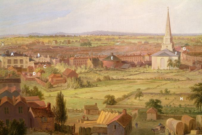
There are a number of topographical paintings of the absent landscape of Birmingham, but this one by Samuel Lines Senior gives one of the best impressions of the town as the perspective is taken from a central position outwards, rather than looking towards the whole town from a distance. It was painted in about 1821, and although it is not a panorama (as discussed in this previous post) as it does not go round 360 degrees, it is panoramic, in the sense that it is an elongated field of view like that captured by a wide angle camera-lens. Perhaps Lines was inspired by some of the cityscapes that could be visited in actual the Panorama on New Street (see E below), which encouraged him to produce this vista of Birmingham's own townscape. For his vantage point Lines took the highest point of the town, which happened to accommodate the church of St. Philip's and that building's large dome, and pointed himself south-west. This was in the direction of one of the newer parts of the town, an area that had expanded from the Medieval district from the 1750s onwards. At the fore of the image can be seen the graveyard attached to the church, and the buildings, some still very makeshift, of Temple Row, one of which was Lines's own house which he had built when he had started to do well as a drawing instructor. In the close-up, below, some of the buildings and landmarks have been pinpointed, and you can follow the proceeding links to find out more.
A to E are along New Street
A) Is the Theatre, by the time of the painting, the Theatre Royal.
B) Next to the theatre was Portugal House, a grand Georgian town house, at the time of the painting divided into two properties with a distillery attached.
C) Just over the street is the original Georgian cottage Post Office, which had at its rear...
D) The Post Office yard where the Royal Mail coaches would arrive from 1812.
E) Is the Panorama, where 360 degree actual size paintings were shown.
F & G are in what is now Victoria Square
F) Is Christ Church, the interior of which can be viewed by following the link.
G) Is placed just to the left of the flag that topped Allin's shop, nicknamed The Flag as it always flew the Union Jack. The Town Hall was later built near this spot. In the distance, behind the 'G', is the Canal Offices on Paradise Street.
H) Is the walled garden attached to Bennett's Hill House, the house just out of view on the right. All the green land in that area was the original Bennett's Hill, and had been protected from building work by a clause in the 120 year lease for the house and land. The lease had expired in 1818 and not long after Lines's painting the whole are was built up with two new roads, houses, shops and other businesses.
To see all posts including Samuel Lines Senior's work click here.
NOTES
The painting and drawing are owned by BMAG and the painting is currently on display in the Birmingham History Galleries.
http://www.bmag.org.uk/new-birmingham-history-galleries
Tour of Lost Birmingham Nᵒ.32: The Bull Ring & the Spectacle of Bull Baiting (High Street)
![]() |
| Drawing by Samuel Lines Senior. Held by Birmingham Museum and Art Gallery. |
The Georgian Bull Ring (part of Birmingham's market area, now a shopping centre) would have been a very crowded and muddled hodge-podge of buildings, many of which encroached over the roads and left scarce room for pedestrians, let alone carts. The Shambles was a group of butcher's shops, which can be seen on the right of the image, above, and filled the area leading to St. Martin's church (left). As the town grew this traditional market place became too small and crowded, and so, from 1801, the Bull Ring was cleared of many of the obstructions, including the Shambles. This was done by the Street Commissioners who were in charge of maintaining the town, and especially in keeping the markets running smoothly.
At the time when this whole area was cleared, a small metal ring was removed from the middle of the ground between the Shambles and St. Martin's church. These rings, that were found in other towns too (Ludlow still has a street called Bull Ring), were 'an iron ring that sticketh in the corne market, to which the bulles that are yearelie bated be usallie tied',* and it was one of these rings that had given the Bull Ring its name. Bull-baiting was a popular recreation in markets, dating back to origins perhaps in the 12th century. The bull would be attached to the ring and dogs would be set on it, this was thought to improve the quality of the meat and make it 'softer in digestion',* as well as provide 'sport' for the spectators in the market. In fact, there is evidence that bull baiting was developed not as an entertainment, but solely as the way to slaughter the meat of older bulls, which would often be tough, and was common practice for butchers.** It is no surprise that the Birmingham 'bull ring' was placed by the butcher's shambles, as it would be a short journey from the killed bull to having the meat then placed on sale.
There is very little evidence of the tradition of bull baiting in Birmingham's market, but if bull baiting began less as a sport and more as the common process of slaughter, this is not so surprising. The area known as the Bull Ring was first shown on the 1778 map, before that (1750 map) it was just the Shambles and the corn market recorded, so it could be that the ring was a late addition to the market area and the practice relatively short lived within the market place. Equally so, the actual ring could have been in place for many, many years, but the area only became known as the 'Bull Ring' at this time.
There are some mentions of bull baiting in the records. In the 1760s a man called John Cooper was given permission to bait a bull in the Bull Ring 'whenever he pleased' by the Lord of the Manor,* probably for the supply of baited meat, but Showell tells us that bull baiting was completely prohibited in Birmingham in 1773.* There were still attempts, though, to bait in and around the town in 1777:
'There have been great Disturbances in the Hamlets of Deritend, Erdington, Saltley, and other Places, in or near this town [Birmingham], occasioned by Bull-baiting, and other Methods made use of to collect disorderly People together, to the great Annoyance of the Publick Peace'.**
The reason for banning bull baiting at this time was less about any mistreatment of the animal and more about unruly groups of people and the 'unsanctioned use of the streets'.**
It was not till the early 1800s that the practice came under any real criticism with regards to cruelty to the animals involved. Although Birmingham was free from bull baiting by this time, many surrounding areas, especially in the Black Country, still maintained a number of blood 'sports', and complaints were issued in the Birmingham Gazette about the custom:
18 March 1828
The 'sport' was also thought to cause drunkeness, and alongside a blood-lust, consequently could lead to violence through fighting and domestic abuse, which are hinted at in the article. Bull baiting was finally banned by law in 1835, though the last known instance in England was in 1838 near Birmingham Heath on the outskirts of the town.*
![]() |
| Bear baiting in a provincial town, 1749. The bear is being taunted and hit with wheel-barrows. |
NOTES
Top image drawn by Samuel Lines Senior
* References on request
** Emma Griffin, England's Revelry: A History of Popular Sports and Pastimes, 1660-1830.
Tour of Lost Birmingham Nᵒ.24: Pratchett's Bull Ring (High Street)
![]() |
| Often described as the work of William Hollins but Thomas Hollins originally made the drawing in mid 1811 and published prints from it in 1812; as recorded in newspapers of the time. |
Drawing of the Bull Ring area and St. Martin's church by Thomas Hollins, 1811.
One of the most changeable sites in Birmingham is the Bull Ring, it has undergone several alterations, each with some contention. The iconic Selfridges building sits, today, just to the left of the church; if it were to be placed in the scene above it would fill the sky above the little Georgian shops, and probably leave the people dumbstruck at what their town will become. The scene today could not be more different, the church is the oldest building but was rebuilt in the 1870s. Admiral Nelson (the statue, centre) still stands watching over her as he did from the day he was first unveiled in 1809.
![]() |
| Mr. Parkes visits Birmingham after a period of time and enthusiastically notes the changes to the main market area around St. Martin's church. 1810. |
In 1806 William Hollins put forward a proposal for the monument of Lord Nelson which the Street Commissioners had proposed, but lost out to Sir Richard Westmacott whose work can be seen above. William’s design was much more complex and expensive in comparison with the simple statue that was chosen and included a post office and dispensary. A year later Pratchett asked him to design the water conduit to surround the pump but the design proved very unpopular. William called the sculpture the 'Egyptian Conduit'; many local people named it 'Pratchett’s Folly'. It was designed as a tribute to Nelson’s victories on the Nile, and may have been an elaborate show of what William could have done with the previous Nelson monument. It was in the shape of a pyramid, combining Egyptian, Grecian and English styles, and was ornamented with papyrus, Grecian honeysuckle and a lion’s head, all with associated mythological symbolism, and crowned with an urn which was a representation of the ashes of Nelson.* It can just be seen in the image above in front of St. Martin’s, just behind the first pair of horses. It seems that the sculpture was thought of as pretentious, with too much symbolism, unlike the statue of Nelson which was a simple tribute.*
Richard Pratchett was, of course, not solely responsible for the changes to the Bull Ring of the early nineteenth century; there were other Street Commissioners, 120 in fact. Yet, in another sense, it was Pratchett's Bull Ring. He had been a major part of the changes, he lived there and saw it everyday through his window, and it probably felt like 'his place', like every other individual might feel like they belong to a place and who make a bond to their location, it is a very human thing.
In 1812 J. C. Stadler produced a coloured version of Thomas Hollins's etching. Above (right) you can see the Georgian St. Martin's church in more detail with 'Pratchett's Pump' by William Hollins tucked into the church wall. Green fields can be seen in the distance. The left imaged depicts shop windows, still looking homely and decorated with curtains; a couple of the shops seem to have small images pasted to the insides of their windows. The full image is below.
NOTES
William Hollins was also commissioned to build the Public Office on Moor Street which was part of the Street Commissioners improvements of this time too. As High Bailiff, Richard Pratchett was the chosen representative of the Commissioners and laid the first stone on 18 Sep 1805.
* References on request
Architectural Change: Whose Redd'ning Fields Rise
![]() |
| Snippet of 1750 map of Birmingham by Samuel Bradford. |
Part of John Dyer's 1757 poem The Fleece.
Thus all is here in motion, all is life:
The creaking wain brings copious store of corn;
The grazier's sleeky kine obstruct the roads,
The neat-dress'd housewives, for the festal board
Crown'd with full baskets in the field-way paths
Come tripping on; th'echoing hills repeat
The stroke of axe and hammer, scaffolds rise,
And growing edifices; heaps of stone,
Beneath the chissel, beauteous shapes assume
Of frieze and column. Some, with even line,
New streets are marking in the neighb'ring fields,
And sacred domes of worship. Industry,
Which dignifies the artist, lifts the swain,
And the straw cottage to a palace turns,
Over the work presides. Such was the scene
Of hurrying Carthage, when the Trojan chief
First view'd her growing turrets. So appear
Th'increasing walls of busy Manchester,
Sheffield and Birmingham, whose redd'ning fields
Rise and enlarge their suburbs.
This part of Dyer's poem begins in the countryside and then slips almost seamlessly from that rural landscape into the urban; there is continuity rather than two worlds opposed. This contradicts the sharp division that is often drawn between the two, and what we might presume to have always been drawn. Dyer compares the rise of these towns to those of ancient Greece; for him the town is a pleasure to behold mainly due to the sophistication of the architecture. This was before the dirt, overcrowding and supposed moral decline that came with the growth of town and industry spurred distaste of urban life. The Birmingham that was rising at the time of Dyer was relatively green; there were still large gardens attached to many of the houses, orchards along what is now New Street as well as trees, there were fields both within the bounds of the town and surrounding it, and most likely wild flowers too. This Birmingham almost melted into the surrounding countryside from which the red brick buildings rose; and the brick as well as the classical ornamentation symbolised learning, taste and civility.
William Hutton in his first visit to Birmingham in 1741 thought the inhabitants of the town ‘marked with the modes of civil life’, and towns were often characterised for their civilising influence. The ‘boorish country squire’ on the other hand was often lampooned in literature,* and those that did sing the praises of the countryside could be those who had been unsuccessful in town ‘celebrating the virtue of contented obscurity’.* For many the country was still boring, intellectually stale and devoid of elegant pleasures. Matthew Boulton noted in 1777 that ‘bull-baitings, cock-fightings, boxing matches, and abominable drunkeness’ were the recreations of Birmingham in the previous century, but that by that year ‘people [were] more polite and civilised’ and that there was ‘considerable progress in some of the liberal arts’. Towns were moving further apart from county life, and were wishing to promote this. A method for promoting a town like Birmingham as a civilised and polite place was often through the architecture; Dyer’s ‘frieze and column’.
Classical styles signified a symbolic memory of ‘the height of civilisation’ which were the Greece and Rome of antiquity. The proportions of elegance and delicate ornamentation of these architectural styles were studied and copied more and more precisely from the late 1500s and permeated slowly into architectural design. The often mathematical styles or orders of classical architecture denoted learning, intellectualism and refinement and by the 1700s classical style was becoming more widespread in the provincial towns as they strived to advertise themselves as refined and cultivated. Through architecture, or so it was believed, the ideas and ideals of the classical age could be transmitted to the citizens of towns. And the town definitely could draw people in, people flocked to towns like Birmingham for work, financial opportunities, refined pleasures, its intellectual culture and its vivacity.
William Cowper was not the first to sing the praises of the countryside when in 1785 he stated ‘God made the country, and man made the town’, asserting that country living was ‘ethically superior’ to living in the town.* Still using classical imagery, the country was being seen as an arcadia, or the realm closer to God, as industrial change began to sharpen the contrast between town and country. Certain aspects of country life were perhaps idealised as country hovels were often no better than the overcrowded areas of towns, and vices were found in the countryside, but the wealth in town’s meant that vice was more marketable. But the smoke, dirt and pollution (including noise pollution) produced through industrial processes cultivated widened aversion to the town’s appearance, and rural retreat became more and more fashionable. The suburbs became what the Birmingham of the 1750s had been (the one praised by Dyer), a place where both the pleasures of the town and of the country could be experienced.
* References available on request.
BOOKS REFERED TO & SUGGESTED READING
Peter Borsay, The English Urban Renaissance
Keith Thomas, Man and the Natural World
M. Christine Boyer, The City of Collective Memory
Tour of Lost Birmingham Nᵒ.6: A Blank Canvas (Bennett's Hill & Waterloo Street)
~1751 map showing (in the grey central area) the Pemberton family home, Bennett's Hill House and the attached garden. Swinford Street became the top end of New Street and Bewdley Street became Ann Street and is now called Colmore Row.~
The previous landscapes of a town influence the proceeding ones and this can be seen in Birmingham. The parts of the town that are the oldest generally have fewer surviving old buildings; they were often the first areas to be redeveloped when the town altered its image. These are areas such as the Bull Ring, Spiceal Street, Moor Street, Dale End, High Street and the bottom end of New Street (the top end of New Street by Victoria Square is relatively new). Also, being the primary shopping streets, these are the places that the town planners would decide place new and innovative buildings. The growing town spread out from these streets; the further the distance from them, the newer the street and the more chance of finding older buildings. If we were to go north-west for example, from the top end of New Street up the roads leading from it to St. Philip’s (such as Temple Street) and to the buildings around the church then to Colmore Row and the roads leading off that we would find many buildings that are generally mid to late Victorian. These replaced buildings that were initially built around the 1740s and 1750s. Further out still is the area around St. Paul’s where a large number of the original buildings from the 1780s still survive, probably, in part, because that part of the town was divided from the central district by the inner ring road.
Bennett’s Hill and Waterloo Street are exceptions in this, as their primary architecture dates from the 1820s and 1830s. There is very little architecture of this period that survives in the central areas apart from in these two streets, and the fact that there is a focus of this period here is peculiar. These two streets are right in the middle of the area that was being built up in the mid 1700s, but the land that they cover was once the large garden of a grand house; Bennett's Hill House. The house had been built in 1698 by John Pemberton outside the town on the top of Bennett’s Hill, which was at that time, just a hill. The lease for the land of the house and garden was for 120 years, and in 1748 Thomas Pemberton (John’s son) added a clause that the land could not be built upon for the term of the lease to protect the elegant gardens and tree lined walks that he had created (see map above).
Little snippets of the land were cut away over the next 70 years, the corner was negotiated for the building of a free church in 1805, and houses popped up along the edges adjoining New Street and Ann Street, but the vast bulk of the land was not able to be built on till 1818. William Hutton stated that prospective builders were just waiting for ‘a word from the owner to speak the houses into being’.* It took a few years for the two new roads to be cut across the land, but after that houses, offices, banks and other buildings quickly lined them; it was a blank canvas for the architects of the age to fill. Several architectural additions were from Charles Edge, John Fallows and Rickman & Hutchinson. At the same time many of the older buildings along the sides of New Street and Ann Street that joined the land were replaced, some of these survive on Ann Street (now Colmore Row), but none on New Street.
It was the relative newness of Bennett’s Hill and Waterloo Street that meant that the Victorians replaced so few of the buildings when they revamped this whole area from the about the 1860s onwards, the newer buildings are mainly of the twentieth century. Many of the buildings at the bottom of Bennett’s Hill were taken out by bombs, and there has been a great alteration to the St. Philip’s end of Waterloo Street, but there are still a number of the original (and they are original) buildings intact. And all because Thomas Pemberton liked to walk in his garden.
*References on request
Image courtesy of Birmingham Library and Archive Services.
1750 Map of Birmingham
SCROLL DOWN TO SEE A LARGER IMAGE OF THE MAP
The coloured version by Alicja Borowska is sold by Paul Leslie Line who runs Map Seeker, and has also written a book which you can buy from Amazon here.
The text on the left side of the map (top the bottom) is as follows.
'A PLAN OF
BIRMINGHAM
Surveyed in MDCCL [1750]
BY
SAMUEL BRADFORD
and Engraved by
Thomas Jefferys GEOGRAPHER
to His Royal Highness the
Prince of Wales'
'Birmingham is a Market Town situated in the North West part of the County of WARWICK [...] distant from London 88 computed & 116 measured Miles, the present number of Houses are 4107 & Inhabitants 23688.----------'
'This Town has been suppos'd to derive its name from one Birming whose dwelling-house formerly stood here. Ye termination Ham in ye Saxon Langueage signifies home or dwelling place. In ye reign of Edward the Confessor it was the Freehold of one Vluvine & in that of William the Conueror was in possession of William Fitz Ausculf who then resided at Dudley Castle. Henry II by a Grant allow'd them to hold a Market every Thursday in y' Year. In ye 35th of Henry III a Charter was given for two Fairs to be kept annually; one to begin on ye Eve of Holy Thursday, & the other on the Eve of St. John the Baptist.-----------'
'K. Edward VI in the 5th Year of his reign erected a Free Grammar School for Boys which is little inferior to any School in England as to its Revenues. St. Philip's Church was erected in the Reign of King George I who gave 600L toward the finishing of it.----------'
'St. Bartholomew's Chappel was lately built and consecrated in the Year 1750. This Town tho' very large and populous has only two Churches and two Chappels, Viz. St. Martin's & St. Philip's Churches, St. Bartholomew's Chappel which belongs to St. Martin's Parish, and St. John's Chappel in Deritend belonging to the Parish of Aston. [...] there are several Meeting Houses for Dissenters of almost all denominations. A Charity School for Boys & Girls & a large handsome [sic] Workhouse. This Place has been for a long series of Years increasing in its buildings & is superior to most Towns in ye Kingdom for its elegance and regularity, as well as Number & wealth of teh Inhabitants, its prosperity is owing greatly to ye Industry of ye People who have for many Years carried on an extensive Trade in Iron and other Wares especially in the Toy Business which has gain'd the Place a name & great esteem all over Europe.----------'
SCROLL DOWN TO SEE A LARGER IMAGE OF THE MAP
The table on the left-centre of the map is an 'An Alphabetical List of the Streets, Lanes &c. with the Number of Houses and Inhabitants in each'. It lists all of the streets that you can see on the map, how many houses were on each street (listed below as #h) and the number of inhabitants in the whole street. It has been suggested that Bradford did simple calculations to estimate the number of inhabitants in each street, though the average number of inhabitants (in square brackets[ ], calculated by myself) varies to such a degree that would suggest a more thorough calculation. The average population of the streets ranges between 3 (in a single house on Butts Lane) and 8.88 (for Cannon Street & Needless Alley), but because we do not know how Bradford collected his data, the information is less useful. For example, the Square has a very high average number of inhabitants at 8.08, yet it is known that this was an area resided in by the very wealthy, so the high average does not represent poverty; though it may represent a large number of in-living servants, but without more data this can only be presumed. The list follows though, for general interest, but please remember that the average inhabitants data is my own addition.
STREET: #houses then number of inhabitants in street [average inhabitants per house]
ASTON STREET & UPPER GOSTY GREEN: 54h 294 [5.44]
BELL STREET: 39h 179 [4.59]
BEWDLEY STREET: 14h 53 [3.79]
BORDESLEY: 83h 405 [4.88]
BUCKLE ROW: 5h 19 [3.8]
BULL STREET: 140h 819 [5.85]
BULL LANE: 14h 80 [5.7]
BUTTON ALLEY: 4h 18 [4.5]
BUTTS LANE: 1h 3 [3]
CANNON STREET & NEEDLESS ALLEY: 64h 568 [8.88]
CARRS LANE: 36h 207 [5.75]
CASTLE STREET: 25h 162 [6.48]
CHAPPEL ROW: 7h 33 [4.71]
CHAPPEL STREET: 43h 205 [4.77]
CHARLES STREET: 8h 31 [3.88]
CHERRY STREET & CROOKED LANE: 28h 190 [6.79]
CHURCH STREET: 2h 9 [4.5]
COLESHILL STREET: 37h 199 [5.38]
COLEMORE [COLMORE] ROW: 36h 268 [7.44]
COLEMORE [COLMORE] STREET: 58h 359 [6.19]
COOPERS MILL LANE: 7h 25 [3.57]
CORBETTS ALLEY: 4h 19 [4.75]
CORN CHEAPING: 29h 162 [5.59]
CROSS STREET: 1h 4 [4]
DALE END: 181h 932 [5.15]
DERETEND: 198h 1096 [5.34]
DIGBETH: 303h 1646 [5.43]
DOCK ALLEY: 13h 51 [3.92]
DUDDESTON STREET: ----
DUDLEY STREET: 104h 602 [5.79]
EDGBASTON STREET: 151h 879 [5.82]
FARMER STREET: 7h 27 [3.86]
FREEMAN STREET: 16h 137 [8.56]
FROGGARY: 25h 147 [5.88]
ST. BARTHOLOMEW'S STREET: ----
HANDSES SQUARE: 26h 140 [5.38]
HARLOW STREET: ----
HIGH TOWN: 247h 1565 [6.34]
HILL STREET: 3h 16 [5.33]
HINKLEYS: 37h 275 [7.43]
JENNING STREET: 1h 5 [5]
JOHN STREET: 59h 348 [5.9]
KING STREET: 36h 217 [6.03]
LEEK STREET: ----
LEASE LANE: 23h 148 [6.43]
LITCHFIELD STREET: 104h 841 [8.09]
LIVERY STREET: ----
LOWER MINORIES: 11h 58 [5.27]
LOWER PRIORY: 17h 90 [5.29]
ST. MARTIN'S LANE: 11h 49 [4.45]
MASS HOUSE LANE: 16h 77 [4.81]
MILL LANE: 16h 114 [7.13]
MOOR STREET: 195h 1076 [5.52]
MOAT LANE: 43h 252 [5.86]
NEW STREET: 109h 649 [5.95]
NEW MEETING STREET: 21h 149 [7.1]
NEWPORT STREET: 1h ----
NEWTON STREET: 54h 312 [5.78]
OLD MEETING STREET: 34h 231 [6.79]
PARK STREET: 156h 944 [6.05]
PECK LANE: 35h 187 [5.34]
PHILIP STREET: 38h 213 [5.61]
PINFOLD STREET: 97h 532 [5.48]
PITT STREET: ----
POTTER STREET: ----
QUEENS ALLEY: 10h 45 [4.5]
SAND STREET: 1h 4 [4]
SHUTT LANE & WELL COURT: 7h 55 [7.86]
SLAINEY [SLANEY] STREET: 60h 302 [5.03]
SMALLBROOK STREET: 101h 795 [7.87]
SNOW HILL: 84h 471 [5.61]
SPICER STREET: 41h 249 [6.07]
SQUARE: 16h 129 [8.06]
STAFFORD STREET & DITCH: 85h 408 [4.8]
STEELHOUSE LANE: 122h 645 [5.29]
SWINFORD STREET: 5h 19 [3.8]
TEMPLE ALLEY: 3h 19 [6.33]
TEMPLE ROW: 17h 129 [7.59]
TEMPLE STREET: 53h 316 [5.96]
THOMAS STREET: 52h 316 [6.08]
TONKES STREET: 13h 57 [4.38]
UPPER MINORIES: 4h 4 [1]
UPPER PRIORY: 23h 155 [6.74]
WALMER LANE: 2h 9 [4.5]
WEAMAN STREET: 78h 486 [6.23]
WESTLEY STREET: 68h 402 [5.91]
WOOD STREET: 35h 204 [5.83]
WORCESTER STREET: 66h 349 [5.29]
Houses Inhabited: 4058
Houses Uninhabited: 182
Total Inhabitants: 23,688
1731 Map of Birmingham
SCROLL DOWN TO SEE A LARGER IMAGE OF THE MAP
Colour adaption below and also found at Map Seeker
1731 Map of Birmingham by William Westley (probably junior)
It is thought that William Westley (senior) was the designer of much of the Priory Estate, which was an area in the north-west of the town built up in the early Georgian period; this is likely as a street within the area was named Westley Row (as seen on map). The Priory Estate was Birmingham’s first planned estate of houses, the centre-piece of which was a grand square (possible also by Westley), all of which would have displayed the new fashions in street and house building. Urban planning was new in the towns and this can be perceived as the usage of the houses in the Square was restricted, there was a certain amount of uniformity to the houses, and certain areas were built up as a coherent whole. It was probably a certain amount of family pride that encouraged the production of this, Birmingham’s first map; the Westley’s had had a hand in the changing landscape and preserved it through this and a number of prospects that Westley produced at a similar time.
Westley dedicated the map to Edward Digby and William Peyto (Esq.s) who were Members of Parliament for Warwickshire (this was long before Birmingham had any of its own MP’s). This plate is a later copy, as can be determined from the addition of the text ‘in the possession of Theoph. Richards in the year 1789. Nephew to Mr. Westley’. The man mentioned in Theophilus Richards, who is one of the notable Richards family that resided in High Street for many years and whose gun-making business still survives today. The map contains two written sections which read;
On the left: “In the Year 1700, Birmingham Contained 30 Streets, 100 Courts and Alleys, 2504 Houses, 15032 Inhabitants, one Church dedicated to St. Martin & a Chappel to St. John & a School founded by Edward 6th also 2 Dissenting Meeting Houses.”
On the right: “The Increase of this Town from 1700 to ye Year 1731~ is as follows: 25 Streets, 50 Courts and Alleys, 1215 Houses, 8254 Inhabitants, together with a new Church, Charity School, Market Cross, & 2 Meeting Houses. for a further account see [illeg.]”
The map depicts the relatively newly built St. Philip’s church still on the outskirts of the town; in the same area is the grand New Hall, and also off New Hall Lane (but unmarked) id Bennett’s Hill House and you can see the elegant gardens marked at the rear of the house. Much of the top end of what is now New Street is still being used as cherry orchards, as is much of the land (as Walker’s orchard) where Corporation Street now runs, and Corbett’s bowling green also sits adjacent to here. The original moats can be seen encircling the old parsonage of St. Martin’s and the buildings that were the seat of the De Birmingham’s. You can also find a number of industrial landmarks including Lloyd’s slitting mills and Kettle’s steel houses.
The 1731 map is unusual as it was drawn with west at the top, which makes it a little more difficult to compare this with later maps. For this blog I have turned the 1731 map 90° so that north is at the top and edited the street names so that they can be read the correct way up, but I have left all other landmarks as they were. I have also included the map in its original form for its own value.
1778 Map of Birmingham
![]() |
| 1778 Map of Birmingham by Thomas Hanson. Engraved by H/J Roe. |
A LARGER IMAGE CAN BE SEEN BELOW.
The coloured version by Alicja Borowska is sold by Paul Leslie Line who runs Map Seeker, who has also written a book which you can buy from Amazon here.
The actual map is surrounded by black and white illustrations of some of the towns principal buildings. On the right are the two churches St. Martin's and St. Philip's, and on the left is St, Mary's Chapel, St. Bartholemew's Chapel, the Free School, the hospital, St. Paul's Chapel, the Charity School, the Hotel, St. John's Chapel, Mr. Green's House, and, slightly seperate, the New Meeting House.
The Chapel of St. Paul's can be seen in the top left of the mapped area, surrounded by newly cut streets that are still to be built on; much of this area is now incorporated into the Jewellery Quarter and many of these houses-to-be are still standing. At the bottom right the Digbeth and Deritend High Street stretches out with Henry Bradford's estate emerging nearby and at the top right the Aston estates can be seen beginning to be built.
Near the Bull Ring you can find the Shambles (butcher's shops) and corn market topped with a tiny dot which is the Old Cross. St. Philip's church can be seen surrounded by the tree lined promenades which were popular at the time, and just to the left of the church is Bennett's Hill House and its own large garden and tree walks.
The text in the box at the top right of the map reads:
"BIRMINGHAM is a Market Town situated in the North-West part of the County of Warwick, [52-55] North Latitude, distant from London 88 computed and 116 measured miles, the present number of Houses are 7200 and Inhabitants 42550."
"This Town has been suppos'd to derive its Name from one Birming whose dwelling house formerly stood here, the termination Ham in the Saxon Language signifies home or dwelling place. In the reign of Ed. the Confessor it was the Freehold of Vlunine, and in that of William the Conqueror was in possession of William Fitz Assculf, who then resided at Dudley Castle. [..] by a Grant allowed them to hold a Market every Thursday on the Year, in the 35th of Hen: III a Charter was granted for two Fairs to be held annually, one to be held on the Eve of Holy Thursday, & the other on the Eve of St. John the Baptiste, but these Fairs are now held on Thursday in the Whitsun Week, and the other on Michaelmas day."
"King Edw. 6th on the 5th Year of his Reign erected a Free Grammar School for Boys, which is little inferior to any School in England as to its Revenues. St. Philip's Church was erected in the Reign of King George I who gave 600L towards finishing it. St. Bartholomew’s Chapel was lately built and consecrated on the Year 1750."
"This Town tho' very large and populous had only two churches, and two Chappels viz. St. Martin's and St. Philip's Churches, St. Bartholomew’s Chappel which belongs to St. Martin's Parish, and, St. John's Chappel in Deritend belonging to the Parish of Aston, but in the Year 1773, an Act was obtained to erect two more Chappels, one to be called St. Mary's, and the other St. Paul’s, the former of which was built and consecrated in the Year 1774. There are also Meeting houses for dissenters of almost all denominations, A Charity School for Boys and Girls, a large handsome Workhouse and two Theatres."
"This place has been for a long series of Years increasing in its Building, and is superior to most Towns in the Kingdom for its Elegance and regularity, as well as number and wealth of the Inhabitants, its Popularity is owing chiefly to the Industry of the People, who have for many Years carried on an [...] Trade in Iron and other Wares, especially in the Toy business which has gained the place a name and great esteem all over the World."
"In the Year 1768 an Act was obtained to make a Navigable Cut or Canal from this Town to the {Cottimls] and from thence to join the Wolverhampton Canal as [Autherly], which Canal was began in 1768 & completed in 1774."
Subscribe to:
Posts (Atom)