Showing posts with label Maps. Show all posts
Map of Warwickshire, c. 1646
Map of Warwickshire by Jan Jansson produced in about 1646, held at Boston Library in the US (original 42cm by 52cm).
The map shows several coats of arms for the local nobility including Thomas Percye, Richard Nevill and John Dudley.
A close-up of the Birmingham area and a large-scale image are below.
Map of Warwickshire, 1630
A map of Warwickshire produced by John Speed (1551/2-1629) and published in 1630. Birmingham and its surrounding villages can be seen in the top left (see below). There are also detailed maps of the towns of Warwick (Warwicke) and Coventry (Coventree). An original is held at Boston Public Library and can be viewed here.
Tour of Kings Norton & Northfield: The Northfield Map of 1714.....What Remains?
The central part of Northfield parish around the church, as drawn in 1714. Northfield is now a heavily urbanised suburb of Birmingham, six miles south of the centre, but at this time was a village surrounded by farmland. The area around the church is still a reminder of Northfield's Georgian, and even more distant part; with a Norman arch set into the wall of the church, this site has hundreds of years of history. So, what still remains from the time of the map?
![]() |
| The Village Pound, Northfield, 1953. Phyllis Nicklin. |
The pound, which can be seen on the centre-left of the map, was used to tether animals that had escaped their owners, who would have to pay a small fee to have them returned.
![]() |
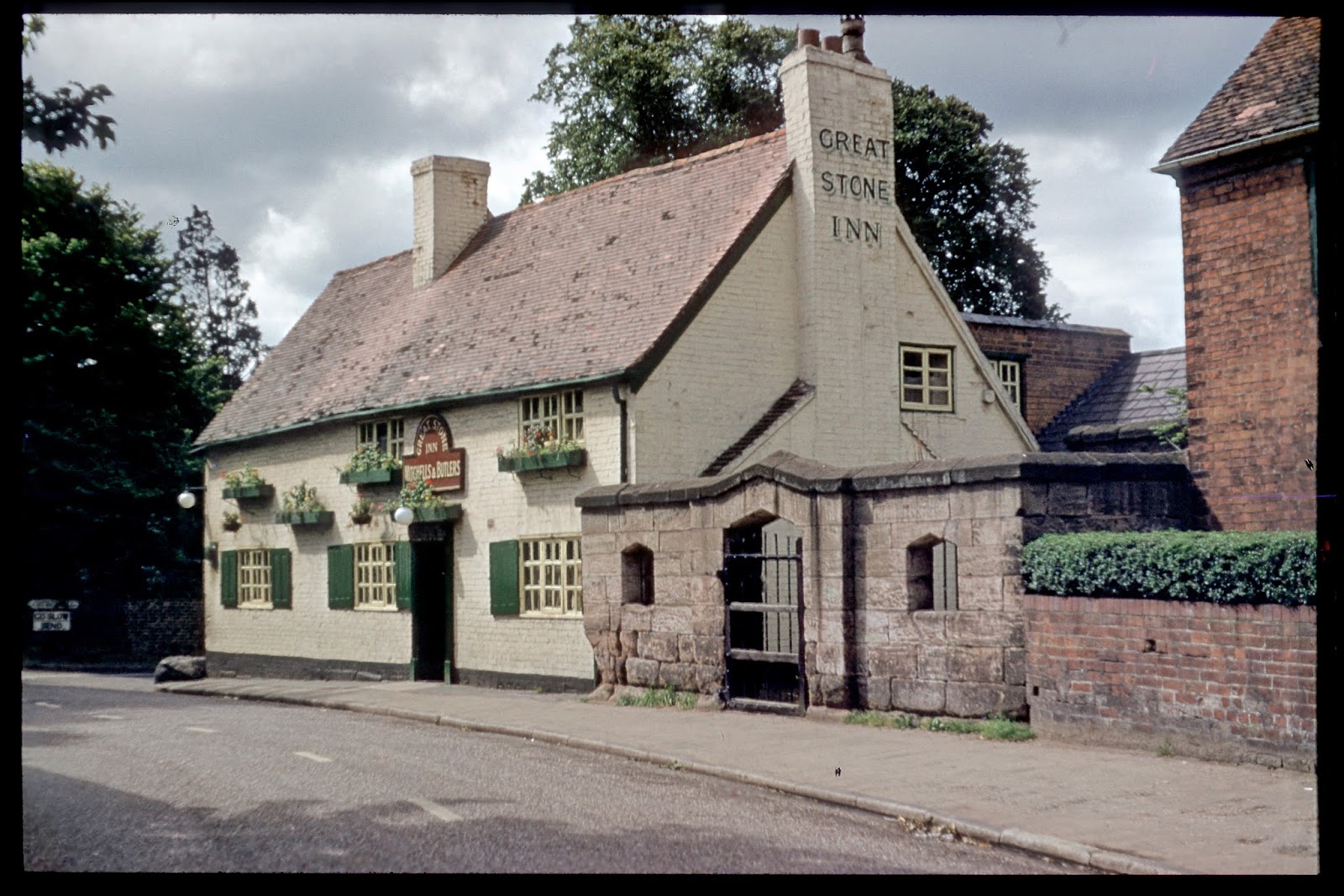
| The Great Stone Inn, next to the pound, 1953. Phyllis Nicklin. |
The Great Stone public house can seen just beneath the village pound on the map, but in reality the two are joined. The name derives from the 'great stone' that was situated at the corner of the pub, which has now been moved (the reason being pretty self explanatory from the image below) and placed inside the Village Pound for safe keeping.
![]() |
| The 'great stone' outside the Great Stone |
At the top of the map, the road leading off to the right states that it leads 'to Middleton Hall'. This road remains as Middleton Hall Road, the remnant of a long demolished smart dwelling house.
![]() |
| The scene including the church by Arthur Lockwood, 1958. |
The parish church can be seen at the bottom of the map, with a path cutting across to the vicarage. The scene that Arthur Lockwood depicted in 1958 is the same as today's, except devoid of cars.
1839 Map of Birmingham
Birmingham. Engraved & printed by J. Henshall, no. 1, Cloudesley Terrace, Islington. London, published by the Society for the Diffusion of Useful Knowledge, May 15th, 1839. (London: Chapman & Hall, 1844).
A Walk Round Regency Brum with the 1819 Map
This map was published in 1819 and was included in the book A Description of Modern Birmingham by Charles Pye. The book also includes observations of the town which fit nicely with the map, and can be found online here. The angle is slightly skewed, with north towards the right.
Below: The buildings in the map have been colour co-ordinated and have an index underneath so that you can find out more about them. Not all the buildings have posts written about them, but they will slowly be added. West is at the top of the map.
BIRMINGHAM in the Year 1819
Click on the orange links below to find out more about each of the buildings on the 1819 map.
RED SECTION
Around St. Philip's Church
1. St. Philip's Church
2. Royal Hotel- Temple Row
3. Rectory of St. Philip's
4. Blue Coat School
ORANGE SECTION
New Street and area behind
top to bottom
1. Christ Church- New Street
2. Panorama- New Street
3. Post Office- New Street
4. Theatre- New Street
5. National School- Pinfold Street
6. Meeting House- King Street
7. Free Grammar School- New Street
8. Meeting House- Old Meeting Street
9. Hen and Chickens Hotel- New Street
YELLOW SECTION
Area of Cannon Street and Union Street
1. Meeting House- Cannon Street
2. Meeting House- near Cannon Street
3. Union Insurance- Union Street
4. Library- Union Street
5. Fire Office- Union Street
6. Dispensary- Union Street
GREEN SECTION
High Street, Bull Ring, Markets and area
along route from...
1. Smithfield Market- Moat Row
2. White Hart Pub- High Street (Digbeth)
3. George Pub- High Street (Digbeth)
4. St. Martin's Church- Bull Ring
5. Bull Ring Market Place & Nelson Statue- Bull Ring
6. Nelson Inn- Bull Ring
7. Public Office- Moor Street
8. Swan Inn- High Street
9. Court of Requests- High Street
10. Castle Inn- High Street/Castle Street
11. Meeting House- Carrs Lane
12. Meeting House- New Meeting Street
TURQUOISE SECTION
Area around Old Square
1. Saracen's Head- Bull Street
2. Stork- Old Square
3. Old Square
4. Quaker's Meeting- Bull Street
5. Meeting House- Steelhouse Lane
6. Poor House- Lichfield Street
to be numbered
BLUE SECTION
Misc buildings: clockwise from top
Crescent- back of Cambridge Street
Albion Mill- Summer Row
Hospital- Summer Lane
Asylum- out of the town
Baths- Blews Street
Nail Manufactory- Blews Street / Brewery Street
Union Mill- Holte Street
Barracks- Windsor Street
Mills- near canal
Spring Gardens- Floodgate Street
[Deritend] Brewery- Bradley Street
Deritend House- Bradley Street
Lady Well Baths- near Hurst Street
St. Martin's Rectory- Edgbaston Street / Smallbrook Street
Unmarked building- Suffolk Street
Lancaster School- Severn Street
Worcester Canal Office
Canal Office- Paradise Street
Gas Works- Gas Street
Brass House- Broad Street
to be numbered
PURPLE SECTION
Misc religious buildings: clockwise from top
Roman Chapel- near King Edward's Place
Meeting House- Newhall Street
St. Paul's Chapel- St. Paul's Square
Meeting House- Bond Street
Roman Chapel- Shadwell Street
St. Mary's Chapel- Whittal Street
Meeting House- Belmont Row
Ashted Chapel- Barlock Street
St. Bartholemew's Chapel- Masshouse Lane
St. John's Chapel- Deritend
Synagogue- near Gough Street
Meeting House- Paradise Street
Jewish Burial Ground- near Worcester Canal
Below: The buildings in the map have been colour co-ordinated and have an index underneath so that you can find out more about them. Not all the buildings have posts written about them, but they will slowly be added. West is at the top of the map.
BIRMINGHAM in the Year 1819
Click on the orange links below to find out more about each of the buildings on the 1819 map.
RED SECTION
Around St. Philip's Church
1. St. Philip's Church
2. Royal Hotel- Temple Row
3. Rectory of St. Philip's
4. Blue Coat School
ORANGE SECTION
New Street and area behind
top to bottom
1. Christ Church- New Street
2. Panorama- New Street
3. Post Office- New Street
4. Theatre- New Street
5. National School- Pinfold Street
6. Meeting House- King Street
7. Free Grammar School- New Street
8. Meeting House- Old Meeting Street
9. Hen and Chickens Hotel- New Street
YELLOW SECTION
Area of Cannon Street and Union Street
1. Meeting House- Cannon Street
2. Meeting House- near Cannon Street
3. Union Insurance- Union Street
4. Library- Union Street
5. Fire Office- Union Street
6. Dispensary- Union Street
GREEN SECTION
High Street, Bull Ring, Markets and area
along route from...
1. Smithfield Market- Moat Row
2. White Hart Pub- High Street (Digbeth)
3. George Pub- High Street (Digbeth)
4. St. Martin's Church- Bull Ring
5. Bull Ring Market Place & Nelson Statue- Bull Ring
6. Nelson Inn- Bull Ring
7. Public Office- Moor Street
8. Swan Inn- High Street
9. Court of Requests- High Street
10. Castle Inn- High Street/Castle Street
11. Meeting House- Carrs Lane
12. Meeting House- New Meeting Street
TURQUOISE SECTION
Area around Old Square
1. Saracen's Head- Bull Street
2. Stork- Old Square
3. Old Square
4. Quaker's Meeting- Bull Street
5. Meeting House- Steelhouse Lane
6. Poor House- Lichfield Street
to be numbered
BLUE SECTION
Misc buildings: clockwise from top
Crescent- back of Cambridge Street
Albion Mill- Summer Row
Hospital- Summer Lane
Asylum- out of the town
Baths- Blews Street
Nail Manufactory- Blews Street / Brewery Street
Union Mill- Holte Street
Barracks- Windsor Street
Mills- near canal
Spring Gardens- Floodgate Street
[Deritend] Brewery- Bradley Street
Deritend House- Bradley Street
Lady Well Baths- near Hurst Street
St. Martin's Rectory- Edgbaston Street / Smallbrook Street
Unmarked building- Suffolk Street
Lancaster School- Severn Street
Worcester Canal Office
Canal Office- Paradise Street
Gas Works- Gas Street
Brass House- Broad Street
to be numbered
PURPLE SECTION
Misc religious buildings: clockwise from top
Roman Chapel- near King Edward's Place
Meeting House- Newhall Street
St. Paul's Chapel- St. Paul's Square
Meeting House- Bond Street
Roman Chapel- Shadwell Street
St. Mary's Chapel- Whittal Street
Meeting House- Belmont Row
Ashted Chapel- Barlock Street
St. Bartholemew's Chapel- Masshouse Lane
St. John's Chapel- Deritend
Synagogue- near Gough Street
Meeting House- Paradise Street
Jewish Burial Ground- near Worcester Canal
Making Improvements: The Street Commissioners
![]() |
| Map of 1810 drawn up by John Kempson for the Street Commissioners. West is top. It shows the administrative boundaries drawn up. |
Apologies, there is no close-up of this map yet.
As Birmingham grew over the eighteenth century the old manorial and parochial institutions became insufficient to maintain the streets and the built environment of the town. With so many inhabitants flocking from all around, buildings were popping up, sometimes with little concern for others, and the medieval streets, that had served well enough before, were now struggling to support the growing town. In 1769 and Act of Parliament was passed to appoint 50 Street Commissioners who could control how buildings were being erected, to improve lighting, to remove obstructions in roads and to widen the narrow medieval streets. Some of the main concerns were to achieve a more effective running of the markets which frequently caused congestion and for the safety of inhabitants by installing lighting. The Street Commissioners were basically an early form of planning body, controlling the way that Birmingham grew for the benefit of the residents as a whole. They Commissioners were deemed to work successfully (most of the time) and their powers were increased by a number of subsequent Acts until the Commissioners were replaced by the Corporation in 1851.*
Following is a list of the Acts that initiated and then added to the work of the Street Commissioners. Their work always centred on improving the markets. The list is not comprehensive, but gives a good outline of their duties over the 81 years of their work.
1769: 50 Street Commissioners were appointed and the first meeting was held at the Castle. To levy the rates, based on the value of inhabitants properties. To make the markets work more effectively (this involved a great deal; Hutton described the markets as "completely choked with buildings and filth). To improve lighting (700 lamps* were introduced and this was so successful that the Act became known as the Lamp Act). To acquire and demolish buildings in order to widen streets (this included houses at the junction of New St/High St, a house by St. Martin's & Upper Roundabout House). To enforce the removal of refuse from in front of properties by householders (they were later responsible for drainage and other waste disposal).*
1773: Number of Commissioners raised to 79. A room to be hired for use as an office. To be able to borrow money at a limit of £1,000. To acquire and demolish houses in Moor Street, New Street, Bull Lane, Temple Tow & Smallbrook Street and to widen New Street, Temple Row & Mount Pleasant (Ann Street). During this period the Commissioners also demolished the Old Cross (1784).*
1801: Number of Commissioners raised to 121. A Public Office and prison to be built (eventually built on Moor Street in 1807). To be able to borrow money at a limit of £5,000. To acquire and demolish the Welsh Cross, houses and shops in Bull Street, Swan Alley, Worcester Street, Moor Street, around St. Martin's and in Bull Ring, including the Shambles (butcher's shops). To control the levels of new streets, to number houses more effectively and to erect street signs. To issue licenses and regulate hackney carriages and sedans.*
1812: Number of Commissioners raised to 220. To be able to borrow money at a limit of £24,000. To repair and maintain the streets, including responsibility for drainage. Gas lighting was introduced during this period (1818). To move the pig and horse markets from Worcester St/Peck Lane to New Street as well as relocating the beast and hay markets (in 1817 markets moved to Smithfield market, opened 29th May, the day of the Whitsun Fair).*
1828: Number of Commissioners raised to 308, which included the Justices of the Peace. The Public Office to be enlarged. To be able to borrow money at a limit of £100,000. To acquire and demolish buildings (300 buildings in 34 streets were demolished). To build a Town Hall (initiated in 1825) and raise funds for it through a special rate.*
The Commissioners were often local notable and wealthy gentlemen, and they chose replacements for vacancies among themselves. William Hutton noted that in his time (written 1795) the Commissioners were sometimes 'irresolute', it being difficult 'to find five men of one mind', and weren't always enthusiastic to attend meetings and get to business.* Hutton also described how Birmingham was 'overgrown with encroaching weeds' which the commissioners seemed to decide was too 'arduous work'.* As well as the body of Commissioners a few staff were hired, for example, treasurers, clerks, rate collectors, scavengers (refuse collectors), surveyors, inspectors of nuisances, market toll collectors and lamp lighters, but sometimes a single individual would cover many roles.*
By 1810 (see map above) the markets were well on the way to becoming clear open spaces; some streets disappeared at this time, like Cock or Well Street and Corn Cheaping.
* References on request
RESOURCES
Minutes from a meeting of the Street Commissioners, 7th May 1777, plus excerpts from 1777 and 1778.
1750 Map of Birmingham
SCROLL DOWN TO SEE A LARGER IMAGE OF THE MAP
The coloured version by Alicja Borowska is sold by Paul Leslie Line who runs Map Seeker, and has also written a book which you can buy from Amazon here.
The text on the left side of the map (top the bottom) is as follows.
'A PLAN OF
BIRMINGHAM
Surveyed in MDCCL [1750]
BY
SAMUEL BRADFORD
and Engraved by
Thomas Jefferys GEOGRAPHER
to His Royal Highness the
Prince of Wales'
'Birmingham is a Market Town situated in the North West part of the County of WARWICK [...] distant from London 88 computed & 116 measured Miles, the present number of Houses are 4107 & Inhabitants 23688.----------'
'This Town has been suppos'd to derive its name from one Birming whose dwelling-house formerly stood here. Ye termination Ham in ye Saxon Langueage signifies home or dwelling place. In ye reign of Edward the Confessor it was the Freehold of one Vluvine & in that of William the Conueror was in possession of William Fitz Ausculf who then resided at Dudley Castle. Henry II by a Grant allow'd them to hold a Market every Thursday in y' Year. In ye 35th of Henry III a Charter was given for two Fairs to be kept annually; one to begin on ye Eve of Holy Thursday, & the other on the Eve of St. John the Baptist.-----------'
'K. Edward VI in the 5th Year of his reign erected a Free Grammar School for Boys which is little inferior to any School in England as to its Revenues. St. Philip's Church was erected in the Reign of King George I who gave 600L toward the finishing of it.----------'
'St. Bartholomew's Chappel was lately built and consecrated in the Year 1750. This Town tho' very large and populous has only two Churches and two Chappels, Viz. St. Martin's & St. Philip's Churches, St. Bartholomew's Chappel which belongs to St. Martin's Parish, and St. John's Chappel in Deritend belonging to the Parish of Aston. [...] there are several Meeting Houses for Dissenters of almost all denominations. A Charity School for Boys & Girls & a large handsome [sic] Workhouse. This Place has been for a long series of Years increasing in its buildings & is superior to most Towns in ye Kingdom for its elegance and regularity, as well as Number & wealth of teh Inhabitants, its prosperity is owing greatly to ye Industry of ye People who have for many Years carried on an extensive Trade in Iron and other Wares especially in the Toy Business which has gain'd the Place a name & great esteem all over Europe.----------'
SCROLL DOWN TO SEE A LARGER IMAGE OF THE MAP
The table on the left-centre of the map is an 'An Alphabetical List of the Streets, Lanes &c. with the Number of Houses and Inhabitants in each'. It lists all of the streets that you can see on the map, how many houses were on each street (listed below as #h) and the number of inhabitants in the whole street. It has been suggested that Bradford did simple calculations to estimate the number of inhabitants in each street, though the average number of inhabitants (in square brackets[ ], calculated by myself) varies to such a degree that would suggest a more thorough calculation. The average population of the streets ranges between 3 (in a single house on Butts Lane) and 8.88 (for Cannon Street & Needless Alley), but because we do not know how Bradford collected his data, the information is less useful. For example, the Square has a very high average number of inhabitants at 8.08, yet it is known that this was an area resided in by the very wealthy, so the high average does not represent poverty; though it may represent a large number of in-living servants, but without more data this can only be presumed. The list follows though, for general interest, but please remember that the average inhabitants data is my own addition.
STREET: #houses then number of inhabitants in street [average inhabitants per house]
ASTON STREET & UPPER GOSTY GREEN: 54h 294 [5.44]
BELL STREET: 39h 179 [4.59]
BEWDLEY STREET: 14h 53 [3.79]
BORDESLEY: 83h 405 [4.88]
BUCKLE ROW: 5h 19 [3.8]
BULL STREET: 140h 819 [5.85]
BULL LANE: 14h 80 [5.7]
BUTTON ALLEY: 4h 18 [4.5]
BUTTS LANE: 1h 3 [3]
CANNON STREET & NEEDLESS ALLEY: 64h 568 [8.88]
CARRS LANE: 36h 207 [5.75]
CASTLE STREET: 25h 162 [6.48]
CHAPPEL ROW: 7h 33 [4.71]
CHAPPEL STREET: 43h 205 [4.77]
CHARLES STREET: 8h 31 [3.88]
CHERRY STREET & CROOKED LANE: 28h 190 [6.79]
CHURCH STREET: 2h 9 [4.5]
COLESHILL STREET: 37h 199 [5.38]
COLEMORE [COLMORE] ROW: 36h 268 [7.44]
COLEMORE [COLMORE] STREET: 58h 359 [6.19]
COOPERS MILL LANE: 7h 25 [3.57]
CORBETTS ALLEY: 4h 19 [4.75]
CORN CHEAPING: 29h 162 [5.59]
CROSS STREET: 1h 4 [4]
DALE END: 181h 932 [5.15]
DERETEND: 198h 1096 [5.34]
DIGBETH: 303h 1646 [5.43]
DOCK ALLEY: 13h 51 [3.92]
DUDDESTON STREET: ----
DUDLEY STREET: 104h 602 [5.79]
EDGBASTON STREET: 151h 879 [5.82]
FARMER STREET: 7h 27 [3.86]
FREEMAN STREET: 16h 137 [8.56]
FROGGARY: 25h 147 [5.88]
ST. BARTHOLOMEW'S STREET: ----
HANDSES SQUARE: 26h 140 [5.38]
HARLOW STREET: ----
HIGH TOWN: 247h 1565 [6.34]
HILL STREET: 3h 16 [5.33]
HINKLEYS: 37h 275 [7.43]
JENNING STREET: 1h 5 [5]
JOHN STREET: 59h 348 [5.9]
KING STREET: 36h 217 [6.03]
LEEK STREET: ----
LEASE LANE: 23h 148 [6.43]
LITCHFIELD STREET: 104h 841 [8.09]
LIVERY STREET: ----
LOWER MINORIES: 11h 58 [5.27]
LOWER PRIORY: 17h 90 [5.29]
ST. MARTIN'S LANE: 11h 49 [4.45]
MASS HOUSE LANE: 16h 77 [4.81]
MILL LANE: 16h 114 [7.13]
MOOR STREET: 195h 1076 [5.52]
MOAT LANE: 43h 252 [5.86]
NEW STREET: 109h 649 [5.95]
NEW MEETING STREET: 21h 149 [7.1]
NEWPORT STREET: 1h ----
NEWTON STREET: 54h 312 [5.78]
OLD MEETING STREET: 34h 231 [6.79]
PARK STREET: 156h 944 [6.05]
PECK LANE: 35h 187 [5.34]
PHILIP STREET: 38h 213 [5.61]
PINFOLD STREET: 97h 532 [5.48]
PITT STREET: ----
POTTER STREET: ----
QUEENS ALLEY: 10h 45 [4.5]
SAND STREET: 1h 4 [4]
SHUTT LANE & WELL COURT: 7h 55 [7.86]
SLAINEY [SLANEY] STREET: 60h 302 [5.03]
SMALLBROOK STREET: 101h 795 [7.87]
SNOW HILL: 84h 471 [5.61]
SPICER STREET: 41h 249 [6.07]
SQUARE: 16h 129 [8.06]
STAFFORD STREET & DITCH: 85h 408 [4.8]
STEELHOUSE LANE: 122h 645 [5.29]
SWINFORD STREET: 5h 19 [3.8]
TEMPLE ALLEY: 3h 19 [6.33]
TEMPLE ROW: 17h 129 [7.59]
TEMPLE STREET: 53h 316 [5.96]
THOMAS STREET: 52h 316 [6.08]
TONKES STREET: 13h 57 [4.38]
UPPER MINORIES: 4h 4 [1]
UPPER PRIORY: 23h 155 [6.74]
WALMER LANE: 2h 9 [4.5]
WEAMAN STREET: 78h 486 [6.23]
WESTLEY STREET: 68h 402 [5.91]
WOOD STREET: 35h 204 [5.83]
WORCESTER STREET: 66h 349 [5.29]
Houses Inhabited: 4058
Houses Uninhabited: 182
Total Inhabitants: 23,688
1731 Map of Birmingham
SCROLL DOWN TO SEE A LARGER IMAGE OF THE MAP
Colour adaption below and also found at Map Seeker
1731 Map of Birmingham by William Westley (probably junior)
It is thought that William Westley (senior) was the designer of much of the Priory Estate, which was an area in the north-west of the town built up in the early Georgian period; this is likely as a street within the area was named Westley Row (as seen on map). The Priory Estate was Birmingham’s first planned estate of houses, the centre-piece of which was a grand square (possible also by Westley), all of which would have displayed the new fashions in street and house building. Urban planning was new in the towns and this can be perceived as the usage of the houses in the Square was restricted, there was a certain amount of uniformity to the houses, and certain areas were built up as a coherent whole. It was probably a certain amount of family pride that encouraged the production of this, Birmingham’s first map; the Westley’s had had a hand in the changing landscape and preserved it through this and a number of prospects that Westley produced at a similar time.
Westley dedicated the map to Edward Digby and William Peyto (Esq.s) who were Members of Parliament for Warwickshire (this was long before Birmingham had any of its own MP’s). This plate is a later copy, as can be determined from the addition of the text ‘in the possession of Theoph. Richards in the year 1789. Nephew to Mr. Westley’. The man mentioned in Theophilus Richards, who is one of the notable Richards family that resided in High Street for many years and whose gun-making business still survives today. The map contains two written sections which read;
On the left: “In the Year 1700, Birmingham Contained 30 Streets, 100 Courts and Alleys, 2504 Houses, 15032 Inhabitants, one Church dedicated to St. Martin & a Chappel to St. John & a School founded by Edward 6th also 2 Dissenting Meeting Houses.”
On the right: “The Increase of this Town from 1700 to ye Year 1731~ is as follows: 25 Streets, 50 Courts and Alleys, 1215 Houses, 8254 Inhabitants, together with a new Church, Charity School, Market Cross, & 2 Meeting Houses. for a further account see [illeg.]”
The map depicts the relatively newly built St. Philip’s church still on the outskirts of the town; in the same area is the grand New Hall, and also off New Hall Lane (but unmarked) id Bennett’s Hill House and you can see the elegant gardens marked at the rear of the house. Much of the top end of what is now New Street is still being used as cherry orchards, as is much of the land (as Walker’s orchard) where Corporation Street now runs, and Corbett’s bowling green also sits adjacent to here. The original moats can be seen encircling the old parsonage of St. Martin’s and the buildings that were the seat of the De Birmingham’s. You can also find a number of industrial landmarks including Lloyd’s slitting mills and Kettle’s steel houses.
The 1731 map is unusual as it was drawn with west at the top, which makes it a little more difficult to compare this with later maps. For this blog I have turned the 1731 map 90° so that north is at the top and edited the street names so that they can be read the correct way up, but I have left all other landmarks as they were. I have also included the map in its original form for its own value.
1778 Map of Birmingham
![]() |
| 1778 Map of Birmingham by Thomas Hanson. Engraved by H/J Roe. |
A LARGER IMAGE CAN BE SEEN BELOW.
The coloured version by Alicja Borowska is sold by Paul Leslie Line who runs Map Seeker, who has also written a book which you can buy from Amazon here.
The actual map is surrounded by black and white illustrations of some of the towns principal buildings. On the right are the two churches St. Martin's and St. Philip's, and on the left is St, Mary's Chapel, St. Bartholemew's Chapel, the Free School, the hospital, St. Paul's Chapel, the Charity School, the Hotel, St. John's Chapel, Mr. Green's House, and, slightly seperate, the New Meeting House.
The Chapel of St. Paul's can be seen in the top left of the mapped area, surrounded by newly cut streets that are still to be built on; much of this area is now incorporated into the Jewellery Quarter and many of these houses-to-be are still standing. At the bottom right the Digbeth and Deritend High Street stretches out with Henry Bradford's estate emerging nearby and at the top right the Aston estates can be seen beginning to be built.
Near the Bull Ring you can find the Shambles (butcher's shops) and corn market topped with a tiny dot which is the Old Cross. St. Philip's church can be seen surrounded by the tree lined promenades which were popular at the time, and just to the left of the church is Bennett's Hill House and its own large garden and tree walks.
The text in the box at the top right of the map reads:
"BIRMINGHAM is a Market Town situated in the North-West part of the County of Warwick, [52-55] North Latitude, distant from London 88 computed and 116 measured miles, the present number of Houses are 7200 and Inhabitants 42550."
"This Town has been suppos'd to derive its Name from one Birming whose dwelling house formerly stood here, the termination Ham in the Saxon Language signifies home or dwelling place. In the reign of Ed. the Confessor it was the Freehold of Vlunine, and in that of William the Conqueror was in possession of William Fitz Assculf, who then resided at Dudley Castle. [..] by a Grant allowed them to hold a Market every Thursday on the Year, in the 35th of Hen: III a Charter was granted for two Fairs to be held annually, one to be held on the Eve of Holy Thursday, & the other on the Eve of St. John the Baptiste, but these Fairs are now held on Thursday in the Whitsun Week, and the other on Michaelmas day."
"King Edw. 6th on the 5th Year of his Reign erected a Free Grammar School for Boys, which is little inferior to any School in England as to its Revenues. St. Philip's Church was erected in the Reign of King George I who gave 600L towards finishing it. St. Bartholomew’s Chapel was lately built and consecrated on the Year 1750."
"This Town tho' very large and populous had only two churches, and two Chappels viz. St. Martin's and St. Philip's Churches, St. Bartholomew’s Chappel which belongs to St. Martin's Parish, and, St. John's Chappel in Deritend belonging to the Parish of Aston, but in the Year 1773, an Act was obtained to erect two more Chappels, one to be called St. Mary's, and the other St. Paul’s, the former of which was built and consecrated in the Year 1774. There are also Meeting houses for dissenters of almost all denominations, A Charity School for Boys and Girls, a large handsome Workhouse and two Theatres."
"This place has been for a long series of Years increasing in its Building, and is superior to most Towns in the Kingdom for its Elegance and regularity, as well as number and wealth of the Inhabitants, its Popularity is owing chiefly to the Industry of the People, who have for many Years carried on an [...] Trade in Iron and other Wares, especially in the Toy business which has gained the place a name and great esteem all over the World."
"In the Year 1768 an Act was obtained to make a Navigable Cut or Canal from this Town to the {Cottimls] and from thence to join the Wolverhampton Canal as [Autherly], which Canal was began in 1768 & completed in 1774."
Subscribe to:
Posts (Atom)