Showing posts with label Phyllis Nicklin. Show all posts

Tour of Lost Birmingham Nᵒ.55: Aston Furnace in the 1750s (Aston)


Aston Furnace in 1753, drawn by R. R. Angerstein.**

Aston Furnace, now demolished, was on the Hockley Brook, near where Porchester Street is today. The current site is grade A listed, although it has been built on. The original furnace was for iron and was first noted in 1615. In the late 1600s it was run by the renowned Jennens ironmasters, who also worked Bromford Forge. British History Online states that there is no evidence that the furnace itself was water-powered, but that the brook was used to power the bellows.*

Tour of Kings Norton & Northfield: The Northfield Map of 1714.....What Remains?


The central part of Northfield parish around the church, as drawn in 1714. Northfield is now a heavily urbanised suburb of Birmingham, six miles south of the centre, but at this time was a village surrounded by farmland. The area around the church is still a reminder of Northfield's Georgian, and even more distant part; with a Norman arch set into the wall of the church, this site has hundreds of years of history. So, what still remains from the time of the map?

The Village Pound, Northfield, 1953. Phyllis Nicklin.

The pound, which can be seen on the centre-left of the map, was used to tether animals that had escaped their owners, who would have to pay a small fee to have them returned.

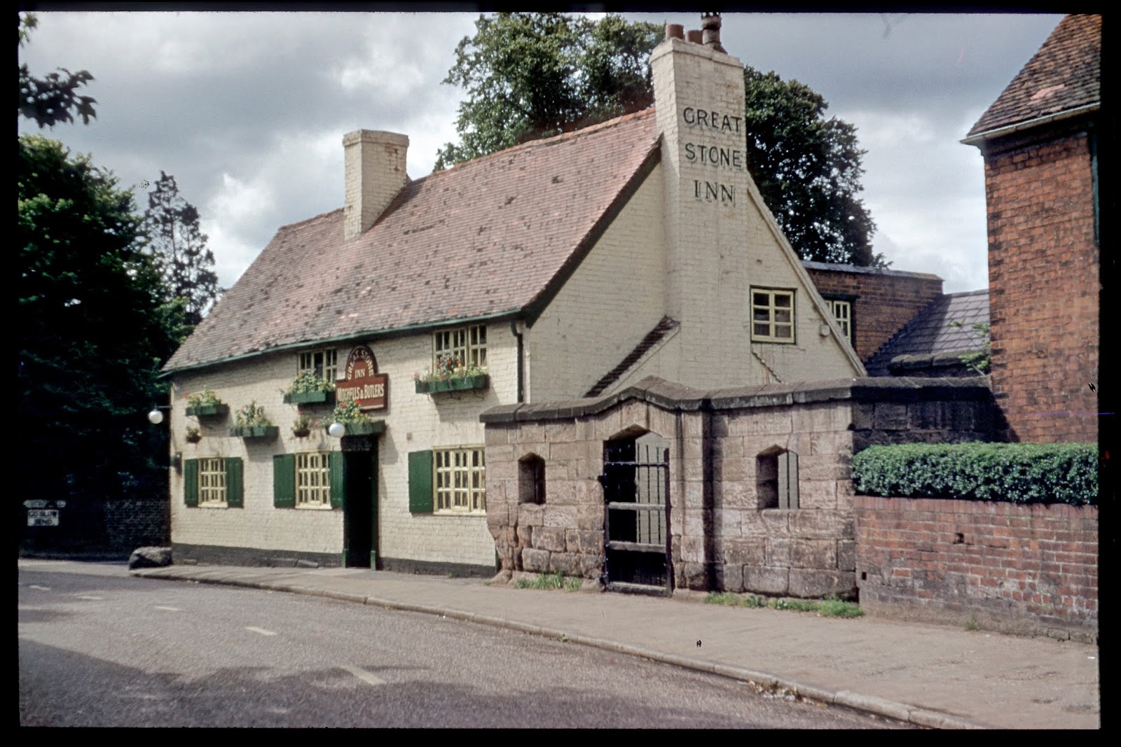
The Great Stone Inn, next to the pound, 1953. Phyllis Nicklin.

The Great Stone public house can seen just beneath the village pound on the map, but in reality the two are joined. The name derives from the 'great stone' that was situated at the corner of the pub, which has now been moved (the reason being pretty self explanatory from the image below) and placed inside the Village Pound for safe keeping.

The 'great stone' outside the Great Stone

At the top of the map, the road leading off to the right states that it leads 'to Middleton Hall'. This road remains as Middleton Hall Road, the remnant of a long demolished smart dwelling house.

The scene including the church by Arthur Lockwood, 1958. 

The parish church can be seen at the bottom of the map, with a path cutting across to the vicarage. The scene that Arthur Lockwood depicted in 1958 is the same as today's, except devoid of cars.

Artisan Districts: The Gun Quarter

Photographs taken in the early 1960s by Phyllis Nicklin. 

It is uncertain exactly when gun making began in Birmingham and its surrounding areas in the West Midlands. When William III came to the throne in 1689 there were gun makers in the town, who benefited from the King keeping the country at near permanent war with France throughout his reign. Technological developments of the gun had led it to be used more reliably in warfare over the previous centuries, and demand was increasing. The gun makers of Birmingham were noted by the government in the late 1600s and several trial orders were made for weapons, eventually leading to contracts being placed with a number of local manufacturers.

The trade expanded over the next fifty years, and like Birmingham's Jewellery Quarter, which still survives to this day, the gun trade also developed in a distinct 'quarter' etched into the landscape of the town. The term 'gun quarter' seems to be a much more modern term than the quarter itself, the district evolved over time through amenity; there were many processes in the making of a single weapon, and each process would be conducted by different skilled workers in separate premises. The making of the guns was divided into two main areas; the component parts were produced by the 'makers' who were breechers, borers, stock makers, barrel welders, bayonet forgers, socket and ring stampers etc, these parts were then assembled by the 'setters up' who assembled to parts to produce the finished article. These were polishers, engravers, browner's, sighters etc. Each finished gun would have gone through about fifty different hands. This method of making guns, due to the complexity of the article, changed little over the years; it was the longest surviving traditional industry in Birmingham.

The 'gun quarter' was concentrated within St. Mary's parish, and many gun makers converted the smart houses that had been built around and near St. Mary's church into manufactories. These have all gone, but in the early 1960s they were beginning to be taken down; Phyllis Nicklin took her camera and recorded some of the area....


But these empty streets lined with cars do little to describe the area at its height; with people and gun parts moving from workshop to workshop the area would have been filled with hustle and bustle, the noise leaking out into the streets from the craftsmen working busily inside at their workbenches. Weaving through the street gunsmiths would be seen:
"one with half a dozen stocked guns on his shoulder, conveying them from the stocker to the screwer, another with a tray full of locks for the polisher, a third on his way with a few barrels to the Proof House, and so on".*

These Georgian frontages also tell us little about the reality of the 'gun quarter' behind the facades, as much of its life was behind the streets. This is 9 to 11 St. Mary's Row, opposite the church, but the two images below are taken behind the same building, and a description from Albert Fenton (below) helps to bring the images to life.

"Some rooms you walked up to from outside on wooden staircases and each had a name-plate on the door. Inside the rooms were very cramped, with the work benches all along the walls [....] The men were working on polishing the gun barrels or carving wood-stocks for handles. There were tools everywhere, hanging on nails and straps all over the walls and lying on benches, you gradually became aware of it all in the dim shafts of light from the small windows. The men were very skilled at their trades which were handed down from father to son"**


NOTES
* Goodman from Skipp
** Albert Fenton from Carl Chinn's, The Great Working City.
PHOTOS
1) Partridge Works on Price Street (off Loveday Street), 1960. 2) No. 3 Whittal Street, 1963. 3) Sand Street near Whittal Street, 1960. 4) St. Mary's Row, 1960. 5) Nos. 9-11 St. Mary's Row, 1960. 6) Behind 9-11 St. Mary's Row, 1960. 7) Behind 10-11 St. Mary's Row, 1963.

Street By Street: Old Bull Street (Ancient Times-Present)


Bull Street formed a junction with Colmore Row (the top part was called Monmouth Street until about 1841), Snow Hill, and Steelhouse Lane at its north end, and with Dale End and High Street at its south end. Beginning in 1878 work began on building the new Corporation Street, which cut through Bull Street and meant that part of it was knocked down.

Image above: The 1841 vista of Birmingham should not be taken as a literal representation of Birmingham, but it provides an impression of Bull Street in the early years of Queen Victoria's reign.

Image below: The image below shows the entire west side of Bull Street in 1840, so around the same time as the vista, above. The top row shows numbers 109-81, and the bottom row shows numbers 80-54 (street numbers went in order at this time, not evens one side and odds the other - that was a Victorian invention).
Walk Up the West Side of Bull Street
Left to Right (109-54)

Held at Birmingham Archive.

Bull Street from High Street, by Samuel Lines, c. 1835.
Held by Birmingham Museums.

Image above: At the corner of Bull Street and High Street was a timber framed building called the Old Lamb House (see post here), demolished in 1886 (photograph taken shortly before demolition). This shows some of the age of Bull Street. This was 108 and 109 Bull Street.

Image Below: Another old house was at 105 Bull Street. In the 1849 directory of Birmingham this was a woollen drapers' run by Whilock Smith.

'Part of a House in Bull St', lithograph by Thomas Underwood, 1865.
Taken from The Buildings of Birmingham Past and Present.

Image below: This conjectural image, certainly produced with help of the street view of the west side (above) shows 93-93 Bull Street where the Cadbury family ran two shops. Number 93 was the tea shop which began selling a new chocolate drink during the Victorian period. Number 92 was the Cadbury drapers' shop. The scene is set in about the 1840s or 1850s. 


Image Below: The photograph below shows some of the surviving Georgian houses. Depicted are numbers 81-79 with a small slice of 78 on the right. Number 81 Bull Street was being by J. Page as a mantle and shawl warehouse both in the photograph below and in the 1840 illustration above


Walk Down the East Side of Bull Street
Left to Right (53-1)

The Quaker Meeting House with blocked up windows, sometime between 1793 and 1857.


Quaker Meeting House was built in 1702 at the top end of Bull Street. In 1793 the site was extended and the windows at the front bricked up. A new Meeting House was built in its place in 1857, which was set well back from the street behind the frontages. Iron Room / Leaflet ?Number 40 Bull Street at the time of the 1841 vista.

Photograph by Phyllis Nicklin, 1960.

Image above: The sign above Simpson, the fishmonger, states that it was established in 1790, and it was still going strong in this photograph from 1960. It was at 6 Bull Street, so the Georgian building to its right was 5 Bull Street.

http://epapers.bham.ac.uk/296/

Images below: At the bottom end of Bull Street where it met Dale End was a rounded building, seen in both the 1841 vista and Samuel Lines's 1835 drawing (both above). This was 1 Bull Street. In the photographs below it was run by Reece Bros as 'Ye Oldest Tobacconyst Shop in Bermyncham'. From at least 1829 to 1849 the tobacconist at number one was Joseph Smout

Bull Street, c. 1888.

Bottom end of Bull Street with the not yet demolished Old Lamb House, so before 1886.