The Absent City Nᵒ.1: Grosvenor House by Cotton, Ballard & Blow (New Street & Bennetts Hill, 1951-3)

Grosvenor House. A rainy day in June 2012.

On the west corner of New Street and Bennett's Hill stands Grosvenor House, built in the early 1950s. There are two previous layers known for this site.

'one of Birmingham's earliest post-war buildings, Grosvenor House by Cotton, Ballard & Blow, 1951-3. The first designs of 1949 were plain. Manzoni asked for some improvement in the architectural treatment and the result has rows of sawtooth projections, little pointed iron ballustrades on the corner, and a brise-soleil. Flashy but undeniably effective'. From: Andy Foster, Birmingham, Pevsner Architectural Guide (London: Yale University Press, 2005), p. 111.

Layer One: Post Office Buildings (1843-c. 1943)

60-54 New Street in circa 1851. Designed by Charles Edge and built in 1843.


Grosvenor House replaced Charles Edge's row of shops and offices built in 1843, which were bombed during WWII. These were called the Post Office Buildings because they replaced the original Georgian post office. Although called Post Office Buildings, the post office had moved over the street. 

Layer Two: Georgian Post Office (c. 1812-c. 1842)

The Georgian post office was older than the street of Bennett's Hill, so it originally stretched along New Street (see image below). Bennett's Hill was laid out in the early 1820s, so the post office building was altered to make it smaller, and other nearby buildings were demolished.

Birmingham's first post office on New Street, c. 1815.

The post office probably opened in the early 1800s, but the building was older. 

Victorian Photo Album Nᵒ.9: Looking Through Windows - Ornaments & Things Inside (Part Four)


The last Looking Through Windows (here, here & here) posts explored 'Greenery in the "Slums"'; and showed that despite these houses being termed 'slums' by officials, the people living them adorned and beautified their homes in multiple ways. 

With a desire to knock down these houses, the photographers took pictures of buildings with cracks in the walls and broken windows, but didn't always notice the little things, the things which can be found by zooming into the old Victorian photographs. 

The previous posts looked at plants and flowers, this one looks at ornaments on window ledges and outside, and other things which can be peeped at by zooming in.  

This Looking Through Windows explores the things that people owned which can be seen in the shadows inside the homes (some door peeking as well as window peeking was necessary). See the images below.....

Tour of Lost Birmingham Nᵒ.61: A Regency Stay at the Hen and Chickens Hotel (New Street)

The Hen and Chicken's on New Street, with King Edward's school to the right, c. 1808.
Coaches would enter the rear stables through the arch.
Held by Birmingham Museums.

Were you at the “Hen and Chickens,” from which I write, however, you would be very well content with your quarters [...] I am surrounded by vases of beautiful flowers, many of them the choice productions of the green house in our rude climate, which ornament and perfume the halls and landings of the staircases, and impart an air bordering on elegance, to the general neatness and comfort of the establishment. The inn at which we are, is said to be the best in this great work-shop of iron and steel [...].*
So noted Charles Samuel Stuart, an American visiting England and Ireland in 1832. He did not remain long in Birmingham, he felt it very modern, and the manufactures that made it worthy of visiting made it smokey and noisy. But Stuart did remain long enough to visit some manufactories before he left. He popped to the Pantechnetheca over the street, and up to St. Philip's church to visit the nearby premises of Edward Thomason on Church Street. Find details of his visit here.

The writer Thomas de Quincey also stayed at the Hen and Chickens in the 1830s, and noted:

as to the noise, never did I sleep at that enormous Hen and Chickens, to which usually my destiny brought me, but I had reason to complain that the discreet hen did not gather her vagrant flock to roost at less favourable hours. Till two or three, I was kept waking by those who were retiring; and about three commenced the morning functions of the porter, or of “boots”, or of “underboots”, who began their rounds for collecting the several freights for the Highflyer, or the Tally-ho, or the Bang-up, to all points  of the compass, and too often (as much happen in such immense establishments) blundered into my room with the appalling, “Now, sir, the horses are coming out.” So that rarely, indeed, have I happened to sleep in Birmingham.**

The Hen and Chicken's, where Stuart and de Quincey stayed, was a coaching inn on New Street built in 1798 'according to the plan of James Wyatt Esq of London'.*3* So stated an article in Aris's Birmingham Gazette that year which informed the Birmingham public that Mrs. Sarah Lloyd was removing the Hen and Chickens from its original site on High Street to its new home on New Street. 

The extent of how important the 'coaching' part of the establishment was can be seen in the sale plan, below, which shows how much land behind the hotel the stables covered. But the building itself was large for an inn of this time, and de Quincey described it as 'colossal'. 

Front elevation and plan of stables for Hen and Chickens, 1836.
Birmingham Archive: MS 3069/13/2/66.

The plan, above, shows the building of the Hen and Chickens with its new portico, protruding porch supported by columns in a classical design, built in 1830. This lent an even grander tone for visitors such as Stuart and de Quincey. It had been built under the hotel's ownership by William Waddell, who took over after Mrs. Lloyd (by at least 1818, probably before). At the same time as building the portico, Waddell converted the front rooms of the premises into 'a commodious restaurant'.*4*

Advert for Wm Waddell's Hen and Chickens, 1830-1835.
Engraved by J. Garner from a drawing by Samuel Lines.
Held by Birmingham Museums.

The view, above, looks along New Street towards Christ Church at the end of the street.


Click here for and image of the Hen & Chicken's from Bisset's Magnificent Directory (1800)/

Notes
The original Hen and Chicken's on High Street, nearby, was called the Angel and Hen and Chickens in the 1740s. It was where the first flying coaches arrived at in 1742, which came from London in two days, something considered amazing at the time (see post on the London to Birmingham stage, here). It also had a fine bowling green attached, bowling being a popular pastime of the mid-Georgian era.*5*

Full references on request. MS 3069/10/345
* here, pp. 42-43.
** Autobiographic Sketches, pp. 291-292.
*3* Dent, p. 304.
*4* Eliezer Edwards, The Taverns of Old Birmingham (1879).
*4* Aris's Birmingham Gazette, 14 December 1741.

Victorian Photo Album Nᵒ.8: Looking Through Windows - Greenery in the "Slums" (Part Three)

Part three (of three parts) of Looking Through Windows (Greenery). See part one, here and part two, here. Please contact to use these cropped images in this way - mappingbirmingham@gmail.com

During the late Victorian period many of central Birmingham's poorer housing was earmarked for demolition in a drive to revamp the city centre and move those living in these houses out to newer homes in the outer parts of the town. Hundreds of photographs of 'slum housing' (Victorian terminology, not mine) were taken of the many courts of back to back housing in the town. These images were taken was to assert the reasoning for their demolition, that they were run down, so they "frame" the buildings to tell this story. This is only one story, though, as these buildings were filled with families living their lives and beautifying their homes, and if you zoom into the images you can find traces of this

Click on the images, below, to view in a lightbox.

Catherine Hutton's Poem on Love & a Cosy Cottage

Held at Birmingham Archive in the Hutton Collection.

A watercolour of a small cottage accompanied by a five verse poem painted and written by Catherine Hutton (1756-1846) of Birmingham.

The poem reads:

Tour of Lost Birmingham Nᵒ.60: Turner's Brass Houses (Coleshill Street, c. 1740)

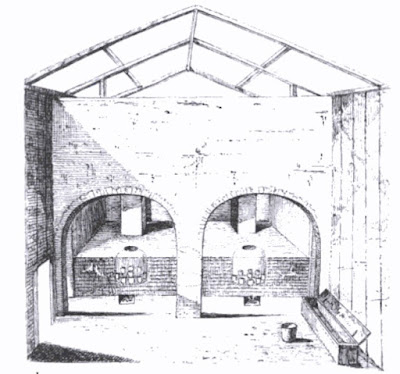
Interior Mr. Turner's Brass Works from R. R. Angerstein's Illustrated Travel Diary, 1753-1755.

Reinhold Rücker Angerstein was a Swedish metallurgist from a family of iron masters, who extensively travelled Britain's industrial works in the early 1750s, including many in Birmingham and nearby. In 1754 he visited Turner's brass works in Birmingham: 
The brass-works [...] belongs to Mr Turner and consists of nine furnaces with three built together in each of three separate buildings. The furnaces are heated with mineral coal, of which 15 tons is used for each furnace, and melting lasting ten hours. Each furnace holds nine pots, 14 inches high and nine inches diameter at the top. Each pot is charged with 41 pounds of copper and 50 pounds of calamine. Mixed with [char]coal. During charging I observed that a handful of coal and calamine was first placed on the bottom of the pot, then came the mixture, which was packed in tightly, followed by about a pound of copper in small pieces, and finally again coal and calamine without copper, covering the top. This procedure was said to lengthen the life of the pot both at the top and the bottom. [...] There are six workers for the nine furnaces and casting takes place twice every 24 hours.*1*

In 1782, William Hutton stated that the 'manufacture of brass was introduced by the family of Turner, about 1740, who erected those works at the south end of Coleshill-street' (see map, below). Although writing in 1783, Hutton first visited Birmingham in the 1740s and moved to the town in 1750, so would have some recollection of the early brass trade. He also said of the works that 'Under the black clouds which arose from this corpulent tunnel, some of the trades collected their daily supply of brass'.*2* Those 'black clouds' can be seen rising from the chimney's of Turner's 'Brass Works' on the 1753 East Prospect of Birmingham:
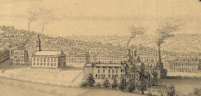
St. Bartholomew's Chapel and smoking chimneys of the brass works, from the East Prospect of Birmingham (1753).

Section of the 1751 Map of Birmingham showing Coleshill Street and Turner's Brass House.


Although this was the beginnings of the manufacture of brass in Birmingham, Birmingham and nearby areas were already making brass things but buying brass produced elsewhere, such as Bristol. Buckles were one such brass thing, and Robert Plot noted the manufacture of 'Poland buckle[s], the pease buckle, chased buckles, Dutch and Irish buckles, which are brass' in Walsall in 1686.*3* John Wilkes was also making beautiful and intricate brass locks in Birmingham in the late 1600s (see post here). The opening of Turner's brass works meant that local makers could now source their brass in Birmingham. 

The 'Mr Turner' noted by Angerstein was Thomas Turner.*4* It is possible that Thomas had made buckles before opening his brass-making works on Coleshill Street, as there was definitely a buckle maker called Thomas Turner working in Birmingham in the 1730s.*5*

In the 1770 Birmingham Directory John and William Turner were 'Proprietors of the Brass Works' at 4 Coleshill Street, possibly sons, or other relatives, of Thomas. William Turner's marriage licence described him as a brass maker.*6*

NOTES
*1* R. R. Angersteins Illustrated Travel Diary: Industry in England and Wales from a Swedish Perspective, 1753-1755, ed. and translated by Torsten and Peter Berg (London: Cromwell Press, 2001), pp. 38-39.
*2* William Hutton, An History of Birmingham (Birmingham: Pearson and Rollason, 1783), p. 329.
*3* Robert Plot, The Natural History of Staffordshire (Oxford: The Theatre, 1686), p. 377.
*4* John Townley, 'Turner’s Brass House, Coleshill Street', published online on The Iron Room.
*5* Turner v Fulwood, 1738, National Archives, C 11/861/79.
*6* Staffordshire, Dioceses Of Lichfield & Coventry Marriage Allegations And Bonds, 1636-1893.
~ https://historywm.com/file/historywm/business-men-and-the-politics-of-the-brass-industry-article-duncan-frankis-final-28482.pdf

Victorian Photo Album Nᵒ.7: Looking Through Windows - Greenery in the "Slums" (Part Two)


Part two (of three parts) of Looking Through Windows (Greenery). See part one, here. Please contact to use these cropped images in this way - mappingbirmingham@gmail.com

During the late Victorian period many of central Birmingham's poorer housing was earmarked for demolition in a drive to revamp the city centre and move those living in these houses out to newer homes in the outer parts of the town. Hundreds of photographs of 'slum housing' (Victorian terminology, not mine) were taken of the many courts of back to back housing in the town. These images were taken was to assert the reasoning for their demolition, that they were run down, so they "frame" the buildings to tell this story. This is only one story, though, as these buildings were filled with families living their lives and beautifying their homes, and if you zoom into the images you can find traces of this

Click on the images, below, to view in a lightbox.

Tour of Lost Birmingham Nᵒ.59: St. Martin's Parsonage (Smallbrook Street)

St. Martin's Parsonage, from a drawing by David Cox and engraved by William Radcliffe, published 25 March 1827. Hand coloured later.

St. Martin's Parsonage was demolished in 1826. The image above was drawn in about 1825 or 1826 by David Cox, and the original drawing is held by Birmingham Museums (see here). The Parsonage housed a long line of the rectors of St. Martin's, and stood a little distance from the church, up Edgbaston Street and at the base of Smallbrook Street.

It was described in 1830, not long after its demolition, as an 'ancient, half-timbered edifice, coated with plaster' and that the 'entrance was through a wicket in the large doors of a long range of low building[s] next to the street'. The building had originally been encircled by a moat, as seen in snippets from the 1731 map of Birmingham below, but only dried-up parts of the moat remained when it was demolished despite the engraving including the moat filled with water.*1* An Act of Parliament was required for its demolition and acquired in 1825, which described the building as 'a most ancient and inconvenient building' which was 'very ill-suited for the residence of the rector'.*2* Parts of it were very ancient indeed.
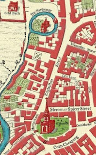
Snippet from 1731 map showing St. Martin's church and parsonage.

Snippet from Bernard Sleigh's version of the 1731 map showing St. Martin's church and parsonage.

Close-up of the Parsonage from  Bernard Sleigh's version of the 1731 map.

The engraving was copied by Charlotte Brontë in about 1832.*3* Brontë never visited Birmingham.

Charlotte Brontë's copy of the 1827 engraving, c. 1832. Private collection.


NOTES
*1* An Historical and Descriptive Sketch of Birmingham (1830), p. 108.
*2* Graphic illustrations of Warwickshire (1829), p. 116. 
*3* Christine Alexander, 'Charlotte Brontë, Her School Friends, and the Roe Head Album', in Brontë Studies, 29, pp. 1-16 (p. 4).
~ MS 1452/2/119/108-109 : LS 908* : L/F/05/31 Local & Private Acts/Vol. 6/17763 : MS 1280/16

Victorian Photo Album Nᵒ.6: Looking Through Windows - Greenery in the "Slums" (Part One)

Original full photograph of 'slum housing',
back of 52 & 54 Midland Street, late 1800s.

During the late Victorian period many of central Birmingham's poorer housing was earmarked for demolition in a drive to revamp the city centre and move those living in these houses out to newer homes in the outer parts of the town. Hundreds of photographs of 'slum housing' were taken of the many courts of back to back housing in the town. These images were taken was to assert the reasoning for their demolition, that they were run down, so they "frame" the buildings to tell this story. This is only one story, though, as these buildings were filled with families living their lives and beautifying their homes, and if you zoom into the images you can find traces of this

Below is part one (of three parts) of Looking Through Windows (Greenery). Please contact to use these cropped images in this way - mappingbirmingham@gmail.com

Click on the images, below, to view in a lightbox.

Paper Remnants Nᵒ.10: G. Hougton & Son "Foremost High Class Gent's Hosier's" (New Street, 1899)

G. Houghton & Son on Birmingham's New Street, 1899.
Printed by W. B. Hill & Co.

See all Paper Remnants.

Victorian Photo Album Nᵒ.5: Monumental Encounters - Framing the Theatre Royal (New Street from Bennetts Hill)

Demolition of the Theatre Royal in 1901.
Held at Birmingham Archive.

Towns have always been gathering points, and anciently the market was a primary draw, as well as other trade opportunities in manufacturing towns like Birmingham. Throughout the eighteenth century, though, the make-up of provincial towns, both architecturally and socially, was changing. Peter Borsay describes an ‘architectural renaissance’ beginning in the late 1600s and early 1700s, with provincial towns beginning ‘to appear visually more attractive and sophisticated’.[1] This occurred along with an increase in social activities as leisure became more in demand in the towns.[2] Wealthier residents and successful businessmen, with more free time, encouraged the building of increasing number of spaces within towns to be used for pleasure and entertainment, and these sites became focal points of the town. In Birmingham these included St. Philip’s with its elegant promenades and later the music festival, assembly rooms and later, in the early 1830s, the Town Hall.

One of Birmingham's most important buildings for its social life and entertainment was the Theatre on New Street, opened in 1774 (later patronised and called the Theatre Royal). The facade was built in 1780 by the renowned architect Samuel Wyatt and was described by one as ‘one of the handsomest theatre's anywhere’.* 

The theatre, later the Theatre Royal on New Street. Image possibly from
about 1800.


When it was built the Theatre stood opposite the other side of New Street, a row of unassuming houses including the Georgian Post Office and its yard. In the early 1820s, though, the site behind the Post Office was redeveloped and two new streets were made, Waterloo Street and Bennetts Hill (see here). Bennett's Hill was deliberately designed to create a frame for the the admired Theatre Royal, and that "frame" is still visible as the theatre was being demolished in the photograph, although the Georgian Theatre Royal itself was very soon to be gone. A new Theatre Royal was to be built, which Bennetts Hill framed for a short time, and now that has been demolished too.

Framing tells us where to look. It takes a section of something, like the urban landscape, and singles it out for particular contemplation, and this is evident in the case of New Street's theatre. One commentator regretted, in 1830, that the theatre had not been built further back from the other buildings on the street to further enhance its prospect, but he cheerfully noted that it could be seen with full effect from the road called Bennett’s Hill which faced it.*


------------

NOTES
[1], [2] Peter Borsay, The English Urban Renaissance
[*] Other and full references on request.
~ The building on the right of the photograph is the Bennett's Hill face of the Post Office Building (never actually a post office but replacing the Georgian cottage post office, hence the name) designed by Charles Edge, and erected in 1842.

Victorian Photo Album Nᵒ.4: The Old Farrier's Arms (Lichfield Street)

Old Farrier's Arms, c. 1880s or 1890s.
Held by Birmingham Archive - WK/B11/1264.

The Old Farrier's Arms was a public house on Lichfield Street, a street which was removed as part of the Corporation Street development, completed in 1903. The buildings were constructed in the eighteenth century, and the pub probably opened in the 1840s. 

In 1849 the Farriers Arms (without the "Old") was being run by George Jones at 100 Lichfield Street. Jones was described as a victualler (old name for a publican) and farrier (a smith who shoes horses).* By 1850 Jones was described as a car proprietor, so owning and running horse drawn cars and carriages.*2* The carriage manufactory next door to the pub, seen in the photograph, was probably set up by Jones. In 1861 the Farrier's Arms was run by Henry Jones, likely George's son, but the address had changed to 123 Lichfield Street.*3* It is unlikely that the pub had moved, but instead the house numbers had altered, as this was common in the Victorian period. 

By 1875 it was the "Old" Farrier's Arms and run by Mary Bowen.*4* 

Victorian Typography and Lamp Design

Patron With Pipe and Bowler Hat

Georgian Door Pediment and Entrance to Carriage Works


Victorian Photo Album Nᵒ.3: "A Kind of Subtle Beyond" on (actually Edwardian) New Street

New Street, 1902.
Held at Birmingham Archive.

Photographs often include things that the photographer did not intend to capture. This is an unassuming shot of some of New Street; the hill rising towards Victoria Square. Roland Barthes called what was outside of the photographer's intention the 'punctum'. For him, the punctum exposed the life that was external to the photograph, "a kind of subtle beyond"*. In the windows of one of the nearer buildings, number 62 in fact, are a couple of strange items. They are barely noticeable without zooming in, but they look like two gaunt, white faces staring out onto the street.


In 1901, the year before the photograph was taken, the Theatre Royal, just a little further up New Street on the opposite side, was demolished and rebuilt by 1902. During demolition, I wonder if much of the scenery and props were placed in storage or sold. Are these two masks or other props that the person inhabiting number 62 has acquired?

Masks and props from the Theatre Royal.
Taken shortly before demolition.

The photograph, above, is from 1901 and depicts a selection of masks that were being stored above the dome of the auditorium in the Theatre Royal. I especially like the donkey's head with the Punchinello (Pulcinella) style face inside its mouth. I wonder what play that was a prop from? Whether or not the strange shapes in the windows of number 62 above are masks or not, it opens up speculation about life beyond the photograph. Someone has placed something pretty eerie in the first floor windows of their shop.

The photograph also captured a conversation.


NOTES
*from Roland Barthes, Camera Lucida, p. 59.
Images courtesy of Birmingham Library and Archive Services.

Victorian Photo Album Nᵒ.2: The Site of the Council House (Victoria Square As It Was)

The corner of Congreve Street and Ann Street (looking up Ann Street), May 1867.
Held at Birmingham Archive.


This is probably the earliest photograph of Ann Street, taken in May 1867, and is an image of the site where the Council House was built between 1874 and 1879. Ann Street is now called Colmore Row. 

As the photographer set up his equipment, seemingly a crowd gathered to have their likenesses captured for prosperity. The image captured James Watts' tobacconist shop, with advertising and the arched entrance to the court behind (probably court 6). The corner building was Bryan's pastry shop opened in about 1849, selling cakes, pies etc, and sweets, which can be seen in the window (see close-up below). This had been previously run as Suffield's chemist's shop and Allin's clothes shop and Cabinet of Curiosites. Bryan's Regency shop-front with Ionic columns is likely a remnant of the time when Suffield ran the shop in the 1820s. The lamp two doors up is attached to the Town Hall Tavern, called such because the Town Hall was situated just behind the photographer as he gazed up Ann Street with his camera. The rest of Ann Street fades into the distance. 

These buildings were built between about 1745 and 1755. The one on the right, on the other side of Ann Street, was built in about 1825.


Bryan's shop with additional signage.

Advert for Bryan's shop, c. 1870s.
Held at Birmingham Archive.

Suburbs (Aston Village): The Serpentine and the Aston Tavern

Aston Church in Aston, near Birmingham, with the River Tame nearby, before the railway
cut it away from Aston village, c. 1830s. 

Today the River Tame seems to skirt past the Aston area; taking a sharp turn under Witton Bridge, and then creeping behind the houses and industries of Tame Road, only to emerge under the Aston Expressway at the other end of Witton. But the old village of Aston grew up along the river, its shape determined by it and especially a large meander, later called the Serpentine. The Tame and its meander formed the north-east border of what was called Aston Manor, a smaller administrative division in the huge parish of Aston, set out at least by the time of George III.* This watery boundary line stretched from Witton Bridge (where the Shire Brook once joined the Tame, forming itself the north-west boundary) to just past Salford Bridge, where the Hockley Brook comes in (which formed the south-east boundary).

The Manor of Aston contained the central hub of Aston Parish; the village, the parish church, and the great manor house called Aston Hall (with its historic deer park), but when the Grand Junction Railway was driven through the area, it drew a line separating the river from Aston Manor. The Serpentine, the meander which lurched too deeply into the village of Aston, was also cut away by the railroad, and left as a motionless arch-shaped pool. More pools formed at its centre, and the nearby Aston Tavern utilised the picturesque ‘Old River Tame’ at the bottom of its sloping ornamental ‘tea gardens’ and platforms were erected for fishing (which was, apparently, excellent, and one of the favourite spots around Birmingham). Further from the Tavern, boathouses were built, and you can imagine summer afternoons with the paddles sweeping against the water, and Victorian ladies reclining with their parasols. It was described in 1838 that the Aston Tavern attracted “a great deal of company in fine weather, from the pleasantness of the situation and the taste displayed in the laying out of the ground”. Its situation during the nineteenth century was a fine one; it stood with a number of other buildings (some timber-built Tudor constructions) along what was called Aston Street (now Witton Lane), with the Holte Almshouses (completed 1656, see images below) standing opposite.

Looking down Aston Street from outside the Aston Tavern in 1897, with
the Holte Almshouses on the other side.
Holte Almshouses.
Aston Street with the Old Aston Tavern on the left, during
the days when the gardens behind led to a picturesque
river remnant; the Serpentine.
The Old Aston Tavern shortly before demolition and rebuild,
with the spire of Aston Church behind.

Moving the River Tame, in 1838, was not the easiest of tasks. The new course was dug out, but the railway line needed to be raised on an embankment to protect it from floods (where it still resides) which kept collapsing, as the riverside ground consisted of thousands of years of soft river deposit. It was the local gravel (from which Gravelly Hill takes its name) which saved the day, and was built up to form a firm foundation for the embankment that would support the heavy traffic on top. These setbacks caused a substantial delay, and the workmen worked “by sunlight and by moonlight” to get the line ready for its official opening.

There has been a settlement near the river here since at least Saxon times, with a moated manor house on the banks of the river just south of where Witton Bridge is today; this was early Aston, though the Saxon’s called it Enstone. Although the house had disappeared, the moat was still drawn into the ground in the days of Birmingham’s first historian, William Hutton (1782), who noted that the trenches were often flooded by the river. By the time of the Domesday Book 44 inhabitants were noted, one being a priest (suggesting that the church was already built), as well as a mill, which would have been water powered and situated along the River Tame. Although probably older, evidence of the village on the banks of the Serpentine Tame can be traced back to the thirteenth century, with finds of pottery (such as cooking pots), a medieval stone wall, and what seem like drainage channels to the river discovered during archaeological digs. Traces of an orchard from the fifteenth and/or sixteenth centuries were also found. It is also possible that a predecessor to the Aston Tavern may have stood on the site in the eighteenth century, as drinking vessels and handled mugs from that period were found during excavations.

Aston Hall with the Grand Junction Railway passing.

In more modern times, the great curve and pools of the Serpentine began to silt up and were eventually filled in. In the 20th century the ancient Onion Fair was moved out of the city centre to the suburbs, and by 1914 had moved to the ‘Serpentine Grounds’. The annual fair remained on this site till about the 1960s or early 1970s.

Birmingham Onion Fair Week. Birmingham Gazette, 1 October 1915.


NOTES
* The parish of Aston was huge and contained a number of administrative divisions: these were Bordesley, Castle Bromwich, Deritend, Duddeston & Nechells, Erdington, Little Bromwich, Saltley & Washwood, Witton and Water Orton. Only Bordesley and Deritend (and the Duddeston part of Duddeston & Nechells) did not have the River Tame as part of their boundaries.

Bisset's Magnificent Directory: Jones, Smart & Co., Glass Manufacturers (Plate W)

Plate W in James Bisset's Magnificent Directory (1800).


A page from Bisset's Magnificent Directory printed in 1800 depicting glass blowing at Jones, Smart and Co. who were glassmakers at Aston Hill in Birmingham.

The frontage of the manufactory was a smart late eighteenth-century structure topped with an urn with the glass cone behind, the glass cone being a chimney with a furnace at the centre and space around for the glassworkers. An underground flue provided a draught forcing the smoke up through the chimney. Glass cones looked like pottery kilns but the similarities were purely aesthetic, and the cone was unique to British glassmaking. Only four survive across the country.*

As well as the central furnace, smaller furnaces were around the edges to keep the glass hot whilst forming it. The image depicts two glassblowers as well as a boy shovelling coal. The curtains drawn back suggest that the process was being revealed to view, and this was very likely the first named glass cone interior depicted in print.**

The four surviving glass cones are the Red House Cone in Wordsley, West Midlands; the Lemington Glass Works in Newcastle upon Tyne; the Catcliffe Cone in the village of the same name in South Yorkshire; and the Northern Glass Cone in Alloa, Scotland.

Notes
* 'Industrial Heritage: British Glass', New Scientist, 63 (1974) 41-42 (p. 42). 
** Jenni Dixon, 'Tourist Experience and the Manufacturing Town: James Bisset's Magnificent Directory of Birmingham', in Pen, Print and Communication in the Eighteenth Century (Liverpool: Liverpool University Press, 2020), pp. 169-183 (p. 177). 
- The Art of Glass Blowing (London: Bumpus and Griffin, 1831).

Birmingham Bookshop Nᵒ.4: South View of from "A History of Birmingham" by William Hutton (1782 (1783 edition))

South view of Birmingham from the summer house, Cheapside, Bordesley, c. 1782.
Click to enlarge.

In 1782 the first history of the town of Birmingham was published by William Hutton, and the image above, depicting a vista of the town, was added as the frontispiece (the image correlates nicely with the 1778 map). Hutton had first come to Birmingham nearly forty years previously and had found it a fascinating town; he was very fond of the place, and his history finally recorded the town's growth on paper.

Key to South View: 1 - St. Martin's Church [see all posts] / 2 - St. Philip's Church [see all posts] / 3 - St. John's Chapel / 4 - St. Bartholomew's Chapel / 5 - St. Mary's Chapel / 6 - St. Paul's Chapel / 7 - Free Grammar School / 8 - The Workhouse / 9 - Theatre in New Street [see all posts] / 10 - Hotel and Assembly Room / 11 - Navigation Office / 12 - Mr. Turner's Brass Work

A digital version of the book, A History of Birmingham, can be found here. This is the second edition published in 1783.

Later Editions of A History of Birmingham by William Hutton
The third edition (1795) is found here scanned on Google Books.
The fourth edition (1819) is found here scanned on Google Books.
The sixth edition (1836) is found here scanned on Google Books.

South view of Birmingham from the summer house, Cheapside, Bordesley, c. 1782.